Relic point Vietnam
Việt Nam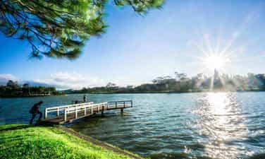
Xuan Huong Lake Relics
When mentioning Da Lat, no one knows about Xuan Huong Lake, a beautiful lake located right in the center of Da Lat city. Xuan Huong Lake is an artificial lake, with a circumference of about 5km and 25ha wide. The lake has the shape of a crescent moon, stretching more than 2 km and passing through many famous tourist attractions of Da Lat such as the City Flower Garden, Yersin Park, Cu Hill and Lam Vien Square. According to people here, the origin of the name Ho Xuan Huong comes from two different legends. The first legend says that every spring, there is a faint, fragrant scent around the lake, ecstatic. That's why people gave the lake the name Xuan Huong Lake. However, the second legend says that Ho Xuan Huong was named after a 19th century Vietnamese female poet named Ho Xuan Huong. Ho Xuan Huong is the author of a number of famous poems such as Floating Water Cake, Life as a Monk, Debt to Husband and Children,... Xuan Huong Lake was originally a large valley, and Cam Ly stream flowed through. In 1919, engineer Labbe blocked this stream so that water could accumulate and form a lake. Then, in 1923, French engineers built a dam at the bottom of the lake, but it broke after a storm in 1932. Engineer Tran Dang Khoa then rebuilt a new dam. made of stone. In 1989, Xuan Huong Lake was recognized by our state as one of the famous landscapes and historical relics in Da Lat, ranked as a national monument. Source: Da Lat tourism information portal
Lam Dong
5423 view
Rating : National monument

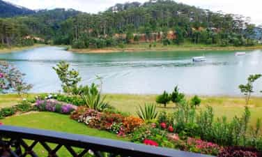
Tuyen Lam Lake Relic in Da Lat
Tuyen Lam Lake was formed in 1985 - 1986. At that time, the People's Committee of Lam Dong province and Duc Trong district deployed troops to build dams to retain water in the Suoi Tia area. Surrounding the Suoi Tia flow area are surrounding mountain ranges that form a basin. When the dam is built to retain the water, it forms Tuyen Lam Lake as it is today. Initially, the main purpose of Tuyen Lam Lake was to store water for main use for irrigation in agricultural production in the downstream area - Hiep An and Dinh An communes in Duc Trong district of Lam Dong province. By 1998, when Tuyen Lam Lake was recognized by the Ministry of Culture, Sports and Tourism as a national historical and scenic site on August 31, 1998, the Tuyen Lam Lake area received even more attention and attention. Not only does it serve irrigation purposes in agricultural production, but it is also used by agencies from central to local levels to guide tourism development planning. Tuyen Lam Lake has an area of 350 hectares; More than 6km south of Da Lat city center. Tuyen Lam Lake area has a fresh climate, quiet space, natural landscapes (forests, mountains, lakes, streams, waterfalls,...) that are diverse, attractive and have many attractive and promising humanistic elements. become a large-scale tourist area with many unique types of tourism such as: sightseeing, camping, relaxation, medical treatment, walking, climbing, fishing, festivals - beliefs, entertainment entertainment, sports,...especially eco-tourism. During the two resistance wars against the French and American invaders, with the location and topography of the Suoi Tia area (now Tuyen Lam Lake) and Elephant Mountain, it was the most important base of the revolutionary movement in Da Lat city and Da Lat city. Tuyen Duc province. This base area serves as a place to direct political and armed struggle movements of the army and people of Da Lat town and Tuyen Duc province, and a place to gather and train the armed forces. , the working teams of the Province and the military region, are the springboard for forces to attack Da Lat and maneuver to fight the enemy on fronts in Tuyen Duc province. During the resistance war against the Americans, in addition to the City Party Committee, there were also military units stationed such as the Financial Department, the clinic, the Women's Work Team, the Youth and Students, the Urban Work Team, and the City Special Forces 850 and 852. , 860... and leading agencies and front units of the province such as the Provincial Party Committee, Provincial Team, logistics, Corridor Station, Company 810 (later to become Battalion 810), Provincial Security Team and forces of the Region 6 as Battalions 186, 145, 200C. From 1982 to 1987, Lam Dong Irrigation Company, invested by the Ministry of Irrigation, built a 235m long dam across Tia stream to create Quang Trung lake, later renamed Tuyen Lam lake. By 2017, the Prime Minister recognized Tuyen Lam Lake National Tourist Area, Da Lat City, Lam Dong Province as a National Tourist Area. Tuyen Lam Lake National Tourist Area was honored by UNESCO as "Typical Asia-Pacific Tourist Area" in the Forum Program "Vietnam - India Cultural and Economic Exchange". Tuyen Lam Lake National Tourist Area has rich tourism resources including natural landscapes, forest resources, climate, cultural and architectural values; Invested and renovated infrastructure along with ongoing investment projects have been promoting value, contributing to affirming the position of Tuyen Lam Lake National Tourist Area on Vietnam's tourism map. South with diverse types of tourism. Source: Management Board of Tuyen Lam Lake National Tourist Area
Lam Dong
5073 view
Rating : National monument
Historical site in Da Lat - Than Tho Lake
Than Tho Lake is located about 6 km east of Da Lat city center, near Da Lat National Martial Arts School (currently the Army Academy). The lake is located on a high hill in the middle of a pine forest, providing a peaceful and quiet space. On the north side of the lake there is a pair of pine trees that evoke the image of a couple, near the scenic Pine Hill Two Tombs with the legend of a broken love. Initially, the Than Tho lake area was just a small pond, and was called Tono Pang Dong. However, in 1917, the French built a lake here to provide daily water for Da Lat. The French named the lake Lac Des Soupirs (meaning "murmuring lake" in French). However, later, the lake was renamed Than Tho Lake by Mr. Nguyen Vy, Chairman of Da Lat Town Council, to express sympathy for the legend of the romantic love story between Hoang Tung and Mai relying on the year of the 18th century here. Than Tho Lake has experienced many ups and downs in history. From the reclamation of mountains and forests in the 1980s - 1990s, to the process of conservation and restoration at the end of 1990. In 1999, Than Tho Lake was recognized and ranked by our state as a scenic spot, national historical relics. Source: Da Lat tourism information portal
Lam Dong
4901 view
Rating : National monument
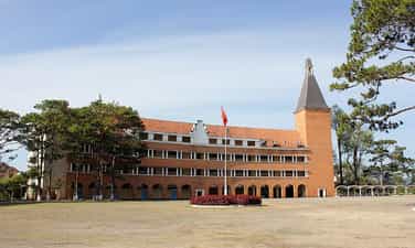
Da Lat Pedagogical College
Da Lat Pedagogical College was established on September 3, 1976 by decision of the Ministry of Education. The school was assigned by the Ministry of Education to become a secondary school teacher training center for Lam Dong province as well as some neighboring provinces. Initially, the school was called Grand Lycée Yersin, built by the French in 1927 for French citizens and some wealthy families to study. The school's main building is designed and built in a unique style and has been recognized by the World Association of Architects. After the victory of the Ho Chi Minh campaign on April 30, 1975, the school was reclaimed by the Vietnamese government and converted into Da Lat Pedagogical College. Currently, the school's buildings have been repaired and upgraded, with new roofing tiles being replaced. The school's special features lie in its 54-meter high bell tower and unique arc-shaped buildings. In 2001, Da Lat Pedagogical College was recognized by our state as one of the historical relics in Da Lat recognized as a national relic. In August 2022, Da Lat Pedagogical College was merged with Lam Dong Economic and Technical College and Da Lat Vocational College, then renamed Da Lat College according to the decision of the Ministry of Labor Movement, War Invalids and Society. Source: Da Lat tourism information portal
Lam Dong
4569 view
Rating : National monument

Dalat Railway Station
Da Lat Station is not only a unique architectural work of Da Lat city, but also a place that makes a special mark in the history of Vietnam Railways. Da Lat Station is located on Quang Trung Street (Ward 10, Da Lat City, Lam Dong Province), also the only train station in the Central Highlands region. Da Lat Station is associated with the history of formation and development of the "land of thousands of pines" urban area, considered the most beautiful ancient train station in Vietnam and Indochina. Da Lat Station was built from 1932 to 1938, located on the Thap Cham - Da Lat railway, connecting the plateau city with Phan Rang (Ninh Thuan). This railway line is 84km long, with an elevation difference of 1,500m, and was started in 1908 by order of Governor General of Indochina Paul Doumer. In 1932, the route was completed, which was also the time to build Da Lat station. The entire route has 12 stations and 5 underground tunnels. It is a special railway because it has 16km of cog railway climbing steeply, with an average slope of 12%. At that time, railways and locomotives with cog wheels only existed in Switzerland and Vietnam. In 1972, this railway line was destroyed by war. In 1975, the country was unified, this line was restored but only operated for a short time due to poor economic efficiency. The rail system and cog railway tracks were removed. The stations were abandoned. Dalat Railway Station was designed by two French architects, Moncet and Revéron, with bold indigenous architecture. The structure of the project is coherent and scientific, but the form is very sophisticated. The building has a symmetrical layout, with the architectural block in the middle simulating the three peaks of Langbiang Mountain and the roofs of the Central Highlands' communal houses; On both sides are two sprawling architectural blocks. In the middle of the building, outside, under the roof, there is a large clock face recording the time Dr. Alexan Dray Yersin discovered Da Lat. In the middle block, there are two front halls, one for passengers and one for cargo. Between these two paths is the train waiting area. This middle architectural block has only 1 floor with large space and a height up to the roof. Overall, the building's architecture is in harmony with nature and is a unique urban highlight. Da Lat Station was recognized as a national historical and cultural relic in 2001. Currently, Da Lat station has been separated from the Vietnam national railway system, but is still an attractive tourist destination. The station maintains a tourist train consisting of 1 locomotive and 4 carriages going back and forth to Trai Mat station (ward 11, Da Lat city), located in the east, 7km from Da Lat, about 25 minutes away. On this road, visitors can admire the romantic suburban landscape of the city. At the last stop is Trai Mat station, visitors can visit Linh Phuoc Pagoda (also known as Ve Chai Pagoda) - a famous and unique pagoda. In addition, Da Lat station still sells intermodal tickets on the Thong Nhat railway, departing from Nha Trang station (Khanh Hoa) and serving Da Lat - Nha Trang transit cars. Along with famous works of Da Lat such as: Cathedral, Bao Dai Palace, Da Lat Pedagogical College..., Da Lat Station is a destination not to be missed for tourists coming to the city. Da Lat. There is also an antique steam locomotive on display and a cafe located in a train car. The station's romantic scenery and ancient architecture is a place where many people come to "hunt" for beautiful photos Source: Vietnam National Tourism Administration
Lam Dong
5399 view
Rating : National monument

Historical relic of Bu Prang Border Guard Station area
On January 4, 2023, the Bu P'rang Border Guard Station area historical relic located in Dak Huyt and Bu P'rang 2 bon, Quang Truc commune, Tuy Duc district, Dak Nong province was recognized as a Monument. Provincial history. Martyrs' Memorial - a place to register and pay tribute to 16 officers and soldiers of the unit who heroically sacrificed their lives in the war to protect the Southwest border in 1977. To serve the task of protecting border security and sovereignty, on May 20, 1975, Bu P'rang People's Armed Police Station (predecessor of Bu P'rang Border Gate Border Guard Station) was established. with an initial force of 32 armed police officers and soldiers sent as reinforcements from Son La province. At that time, the station was assigned the task of managing and protecting national border security and sovereignty with a 16.5 km long border section, located in Quang Truc commune (Dak R'lap district, former Dak Lak province), now known as Dak Lak. Tuy Duc district (Dak Nong), bordering Mondulkiri province, Kingdom of Cambodia. During the war to protect the Southwest border, officers and soldiers stubbornly held on, courageously fought 127 battles, firmly defending every inch of the Fatherland's sacred land. The historical milestone that demonstrated the brave spirit of the soldiers at that time was the battle that lasted 47 days and nights (from March 29 to May 16, 1978) with the Pol Pot gang. The above mentioned victorious fight to protect border security and sovereignty demonstrated the solidarity, determination to fight and willingness to sacrifice of the officers and soldiers of the Bu P'rang People's Armed Police Station. . With that feat, on November 6, 1978, Bu P'ran People's Armed Police Station was honored by the State as Hero of the People's Armed Forces. Bu P'rang Border Gate Border Guard Station is stationed in Tuy Duc district, 35 km from the district center, assigned to manage and protect the 11 km border area, in charge of Bu P'rang 2 border. belongs to Quang Truc commune (Tuy Duc). With the spirit of "The station is home, the border is the homeland, people of all ethnic groups are blood brothers", the party committee and unit commanders have thoroughly grasped and seriously implemented the directives, orders and superiors' plans on tasks and border guard work. Accordingly, along with fully developing combat documents, the station regularly organizes training plans to ensure high combat readiness, proactively detect and promptly handle all situations that arise on the border. border, area, border station. In just the two years 2020-2021, the station organized 676 border patrols, controls and protections with 6,084 officers and soldiers, thereby detecting and handling 10 cases/11 border violators. gender. As a border gate station, the unit maintains strict and lawful immigration and import and export control activities through the border gate, and at the same time advises the Party Committee and local authorities to well carry out people-to-people diplomacy work. , maintain stability and develop cooperative relations on both sides of the border. Source: New Rural Information Website - Dak Nong Province
Lam Dong
4867 view
Rating : Provincial level relics

Serepok Bridge
Serepok bridge was built by the French in 1941, completed, put into use in 1957 and named bridge 14 by the French government (bridge located on route 14), while local people named it Serepok bridge because spanning the Serepok River connecting the two provinces of Dak Lak and Dak Nong. The eastern bridgehead belongs to Hoa Phu commune, Buon Ma Thuot city, Dak Lak province; The eastern bridgehead belongs to Tam Thang commune, Cu Jut district, Dak Nong province. In 1904, the French colonialists began building a governing apparatus, establishing an administrative unit of Dak Lak province and dividing the Dak Lak plateau into five districts. During the invasion, the French colonialists realized the difficulty of traveling on the vital road, affecting their intention to invade and expand their territory. In 1941, the French colonial government decided to build bridge 14 and the bridge was built with the blood of political prisoners in Buon Ma Thuot exile house and local people. The bridge is designed with a continuous reinforced concrete truss structure running underneath, 169.5 m long, 4 spans, 5 m wide, two pedestrian lanes of 1.37 m, vehicle lanes of 2, 8 m, load capacity 5 tons. In the early 40s of the 20th century, Serepok bridge was modern and had beautiful architecture. Entering the period 1954-1975, Route 14 was thoroughly exploited by the US imperialists and the puppet government, with blocking forces deployed to control and block all resources of the Vietnamese army. It was also here that our army and people launched an important offensive to liberate Buon Ma Thuot (Dak Lak) and then towards Saigon, completely liberating the South and reunifying the country. In 1985, facing the development of road transport, the Serepok bridge built during the French period could no longer meet the transport needs in terms of both load and vehicle density, so the Ministry of Transport decided to invest in Investing in the construction of a new bridge to replace the old bridge that has a small load and has deteriorated. The new Serepok bridge was built on Highway 14, 30 meters north of the old bridge. The bridge is 176 m long, has a simple beam reinforced concrete structure, includes 5 spans, 11 m wide, has 2 motor vehicle lanes 7 m wide and 2 walking lanes 1.25 m wide each. The project is invested by Road Zone 5 and constructed by Traffic Construction Company 510 of Transport Construction Corporation 5 under the Ministry of Transport. The bridge was completed and put into use in October 1992. Since then, vehicles traveling on Highway 14 have crossed the new bridge. In 2016, a third bridge between the two bridges was also completed to serve the increasing travel demand on Highway 14. With that meaning, Serepok Bridge was chosen by the People's Committee of Dak Nong province as a heritage site of Dak Nong Geopark under the "Symphony of the New Wind" tourist route. Source: Dak Nong Electronic Newspaper
Lam Dong
4847 view
Rating : National monument
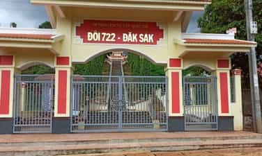
Victory location Hill 722 - Dak Sak
Hill 722 - Dak Sak is a US-Puppet commando base established in 1965. This is where a fierce battle took place between regular troops and local military forces attacking and destroying the commando base on September 19. August 22 and 23, 1968. Hill 722 is at an altitude of 722m above sea level in Tho Hoang 4 village, Dak Sak commune, Dak Mil district. In May 1965, the US - puppet government and the Saigon government built the Hill 722 military base (also known as Duc Lap special forces camp) about 10 km east of the center of Duc Lap district to strengthen their forces. volume and increased military activities. To deal with the enemy's plots and tricks, in 1968 the Politburo and Central Highlands Field Command determined it was necessary to destroy the enemy at Duc Lap district headquarters, whose core was the military base Hill 722 - Dak Sak, one of the enemy's key strongholds on the Central Highlands front. Implementing that policy, during the years 1968 to 1975, our main force coordinated with the local army and people to organize many battles at this base, on the one hand to drain the enemy's vital forces, and on the other hand to defeat the enemy. destroyed the system of posts that were sabotaging the Ho Chi Minh Trail on the Southern Central Highlands battlefield. After 1968, after many heavy defeats in the Southern Central Highlands battlefield, the enemy retreated and entrenched in military bases, in which Hill 722 - Dak Sak was an important military base. From here, they continued to implement the policy of gathering people to form hamlets. Faced with that situation, to maintain the posture, the Quang Duc Provincial Party Committee directed the Dak Mil District Party Committee, determined to overcome difficulties, implement the "three clings" (cadres cling to the people, people cling to the land and guerrillas cling to the enemy). continue to fight the enemy, promote the construction of rear bases, increase production, and ensure food supply for the front; Expand the liberated area, push the enemy into a clustered position, and prepare to fight with the people of the whole country. By 1975, Dak Sak and Duc Lap strongholds were completely wiped out by our troops. After the liberation day, to commemorate the great sacrifice of our officers and soldiers at Hill 722 - Dak Sak in particular, and in the Duc Lap campaign in the fall of 1968 in general, Dak Nong province established a memorial to them. heroic martyrs. On October 24, 2012, Hill 722 relic - Dak Sak was recognized by the Ministry of Culture, Sports and Tourism as a national historical relic. Currently, Hill 722 - Dak Sak Historical Site has a total area of nearly 4 hectares. On this site, there are still some relics and military equipment, such as shoes, hats, and bullet casings. In 2010, Area I of the monument was invested by the State to build a memorial stele house, green campus and fence with a total construction investment area of 2,485m2. Every year, the relic serves over 1,000 visitors to visit and study. This is a historical relic of great significance in traditional education, political awareness for the young generation, and gratitude for the great contributions of our ancestors. It is one of the historical milestones in the struggle for national liberation of the Party Committee and People of Dak Nong province in particular and Vietnam in general. Source: Dak Nong Electronic Newspaper
Lam Dong
4622 view
Rating : National monument
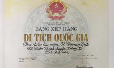
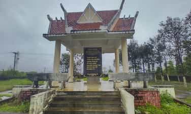
Historical relic N'Trang Guh memorial site
Based on local historical records and the accounts of some village elders in Krong No, N'Trang Guh, real name Y Guh, is an Ede ethnic person, born around 1845, in Choáh Kplang village, now in the commune. Buon Choáh (Krong No). Legend has it that N'Trang Guh was talented, virtuous and a good hunter in the village, so he had many valuable possessions such as rhino horn and ivory. Not only that, he also knows how to calculate business well, so every time the season comes, he always harvests a lot of rice and corn, raises many buffaloes, cows, pigs, chickens... and has a reputation in near and far villages, and is loved by everyone. beloved person. In addition to being rich in wealth, he is also a compassionate person because he always guides people through experiences in hunting, animal husbandry, and farming and is willing to help the poor, in need, and with crop failures. In 1884, the Siamese army waged a war of invasion, capturing the lower reaches of the Krong No and Krong Ana rivers. Responding to N'Trang Guh's call, people in 20 Bih ethnic villages living in the Krong No and Krong Ana river basins stood up against foreign invaders. The insurgent army commanded by N'Trang Guh had up to 600 people, had no guns, only used rudimentary weapons: bows, arrows, spears... In order to increase their strength, N'Trang Guh created a fairly good crossbow. special, not found anywhere else. The crossbow is longer than a person's head, the side is one hand wide, and shoots 3 arrows at a time. With this powerful weapon, combined with the spirit of courage, tenacity and cunning, in 1887, the N'Trang Guh insurgent army surrounded and destroyed the entire Siamese army right on the fields of Tur and Phok villages. The glorious victory of the N'Trang Guh insurgent army crushed the invasion of the Siamese army, helping the people feel secure in working in production and building villages. In the early years of the 20th century, the ruling apparatus of the French colonial government acquired and controlled almost all the trading and trading of indigenous people in the Central Highlands. Bourgeois, the first French envoy in Dak Lak, blatantly used military force to drive the Ede and M'nong people to other places, taking over villages, villages, land, fields, and water wharves to Establish plantations and build a system of posts. The compatriots were forced to work as laborers on French plantations, and they had to work 14 to 15 hours a day. In early 1900, the French army invaded the villages of the Bih people along the Krong No and Krong Ana river basins. N'Trang Guh led the insurgent army to fight against the invaders, the most famous being the battle to destroy the Tur garrison. One morning in 1901, under the direction of N'Trang Guh, the insurgents crossed the Krong No River to surround Tur station, used crossbows to shoot many enemy soldiers, and then attacked the station. In just a short time, all the enemy troops stationed here were destroyed. The colonialist Buoc Gioa, who had a lot of blood debt to the people, died in front of the station yard. Taking advantage of the victory, the insurgents continued to attack, one by one destroying other colonial posts such as Jiang post, Dur post... With the skillful and courageous leadership of N'Trang Guh, the insurgents fought fought for 13 years. In 1914, because there was a traitor in the ranks of the insurgent army, the location of N'Trang Guh's station was revealed, so he was arrested by the French and sentenced to death. After N'Trang Guh passed away, his body was brought back by the people to be buried in his hometown, where he was born, Choah village, Choah village (Krong No). To remember the place that left many illustrious marks of the chief of Ede village, a hero of the Central Highlands peoples, on August 2, 2011, the Ministry of Culture, Sports and Tourism ranked N'Trang Guh souvenir site is classified as a national historical site. Source: Krong No District Electronic Information Page
Lam Dong
4871 view
Rating : National monument
The historical site connects the Central Highlands to the Southeast
The historical relic of Cay Xoai village is a contact point to open the North-South strategic corridor, the section through Dak Nong province. On May 25, 1959, the Central Military Commission and the Ministry of National Defense officially established Group B90, with the mission of secretly going to the South with on-site units to build facilities and open two routes to the East and West. from the Southern Central Highlands to the Southeast region - where the Southern Party Committee is located. Overcoming difficulties, sacrifices and even unsuccessful connection trips, finally, at about 4:00 p.m., October 30, 1960, the B90 Working Group made contact with the C200 working group of the Southeast region. Ministry at Cay Xoai village, Dak Nia commune, City. Gia Nghia, Dak Nong province. On November 4, 1960, at kilometer 4 on the Dak Song to Gia Nghia road, the western wing of Group B90 continued to make contact with unit C270 from the Southeast. This is an event of particularly important strategic significance. The North-South strategic corridor was opened, becoming an important node to help smooth the Ho Chi Minh route, from here, the transport route Military strategy Ho Chi Minh Road is like a lifeline running from North to South, providing timely human and material resources from the great rear of the socialist North to the great front line of the South, making a decisive contribution to victory. greatness of the resistance war against the US to save the country. From 1961 to 1965, the Ho Chi Minh Trail was smooth, and tens of thousands of Southern compatriots gathered to go to the North and returned to the battlefield; A series of essential items such as parcels, official documents, weapons, ammunition, including liberation radio equipment... were urgently transported by soldiers between the East and West wings. provide support for the battlefields of the South and the extreme South Central region; Transporting high-ranking Party officials to the South to lead the masses in the fight against America. After a period of operation, the base in the Southern Central Highlands was expanded and connected to areas with bases in Tay Khanh Hoa, Tay Ninh Thuan, Dak Lak, Lam Dong and connected from Dak Mil to war zone D. In addition, the Quang Duc corridor force coordinated with Cambodia to expand the control area along the corridor, creating effective continuity and coordination across battlefields during the resistance war. To achieve the miracle of connecting the battlefields, making an important contribution to the great victory of the resistance war against the US, it is impossible not to mention the role of ethnic people in the area who sacrificed their lives, arduously protecting the corridor, protecting forces participating in military transport on Truong Son road, hiding officers, protecting the revolution, ensuring smooth operations. These are the boys and girls of Group H50 who stick to the road, despite hardships and deprivation; They are groups of local civilians who secretly carry goods and weapons to overcome high passes, steep slopes, muddy fields and dangerous posts; That is the image of 800 compatriots at Nam Nung base having to eat forest leaves and tubers to save rice, corn, potatoes, and cassava to help the road construction team and officers and soldiers walking on the corridor, despite the dangers to get there. raise troops, protect revolutionary soldiers... Cay Xoai village historical relic "Place to establish communication to open the North-South strategic corridor, section through Dak Nong province" is one of the historical places associated with the miracle of the 20th century - Duong Truong Son, invested in construction by the State and completed on March 23, 2010. On August 2, 2011, the Ministry of Culture, Sports and Tourism recognized this as a national revolutionary historical relic. On October 30, 2017, the People's Committee of Dak Nong province organized a memorial ceremony and placed a stele listing the list of officers and soldiers who participated in fighting and sacrificed their lives in carrying out the tasks of construction and protection. North-South strategic corridor, in Cay Xoai village, Dak Nia commune, City. Gia Nghia, Dak Nong province. Source: Party Committee of Agencies and Enterprises of Dak Nong Province
Lam Dong
9113 view
Rating : National monument