


Why did King Hung choose Phong Chau as the capital's land: The Strategic Vision of His Father
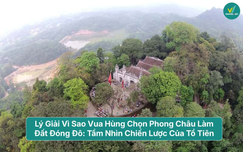
In the thousands of years of history of the Vietnamese people, the Hung King era was the first brick to build the Van Lang national foundation. One of the big questions that always attracts the attention of historians, archaeologists and people nationwide is: Why did King Hung choose Phong Chau (now Phu Tho) as his capital?
Choosing the capital is not simply finding a place to reside, but it is a millennium-sized decision, demonstrating the sharp geopolitical, military and economic thinking of our predecessors. This article will explain in detail the core causes from a professional and scientific perspective.
Geopolitical Position: "Converging People - Gathering Water"
From the perspective of feng shui and ancient administrative geography, Phong Chau land possesses a position that few places have. This is considered the intersection point between the high mountains and the lower plains.
Convergence point of three great rivers
Phong Chau is located in the "Hac Junction" area - the convergence of the three largest rivers in the North: Red River, Da River and Lo River.
About transportation: At that time, waterways were the only lifeline for trade and transportation. Mastering the river junction helps King Hung easily control travel and link tribes from the uplands to the lowlands.
Military: Rivers act as giant natural trenches, protecting the capital from invasions by Northern tribes or hostile forces along the river banks.
"Left Blue Dragon, Right White Tiger"
The Hung Temple area (Nghia Linh mountain) is surrounded by a system of undulating hills and mountains like a dragon flanking a tiger. Behind is the majestic Tam Dao range as a fulcrum, in front overlooking the open river. According to the concept of the ancients, this is the land of "mountains and water gathering", where the spiritual energy of heaven and earth is concentrated, very suitable for laying the foundation for a sustainable dynasty.
Phu Tho is where the three largest rivers in the North meet
Economic Advantages of Agriculture and Mining
If a country wants to be strong, its economy must be stable. At the beginning of wet rice civilization, Phong Chau was the number one choice.
Fertile alluvial land
Thanks to the sedimentation of three large rivers, the land around Phong Chau is extremely fertile riverine plains. This creates favorable conditions for ancient Vietnamese residents to develop wet rice farming - the main economic foundation of the Van Lang nation.
Resource diversity
Located in the transition zone between mountains and plains, residents here can exploit resources from both areas:
Mountain areas: Providing forest products, wild animals, raw materials for weapons and production tools (copper, stone).
Underwater: Provides abundant aquatic resources from a dense river system.
Food abundance is the factor that "nurtures" military strength and helps the population concentrate, creating a strong community.
Phu Tho's terrain has both mountainous and plain areas
Strategic Vision on National Defense
The Hung Kings demonstrated military thinking beyond their time when choosing Phong Chau as the national "operations center".
Ideal observation location: Standing on the top of Nghia Linh mountain, you can observe a large surrounding area. Any movement of enemy troops by waterway or road can be easily detected from afar.
Defensive posture in depth: If the border area is attacked, the steep mountainous terrain and divided rivers in Phong Chau will become a natural trap, slowing down the enemy's advance, creating conditions for Van Lang's army to organize a counterattack.
Bonding the great national unity bloc: Located in the center of 15 tribes at that time, Phong Chau capital acted as the connecting nucleus. When an incident occurs, the mobilization of human resources from the tribes to the center is fastest.
Cultural and Spiritual Values
The history of choosing a capital is not only based on material things but also on spiritual beliefs. Ancient Vietnamese people had a belief in worshiping mountain gods and river gods.
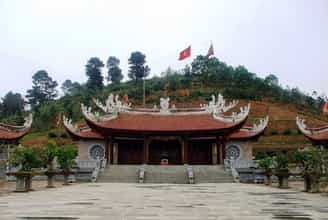
Nghia Linh Mountain (Hung Mountain) with its outstanding height among the flat hills is considered the junction between Heaven and Earth. Placing the capital at the foot of the sacred mountain and establishing a temple on the top of the mountain helped King Hung assert his authority as the "Son of Heaven" (Son of Heaven), while also creating a solid spiritual fulcrum for the entire nation. This is the origin of the belief in worshiping Hung Kings - a representative intangible cultural heritage of humanity.
The peak of Nghia Linh mountain where the Hung Kings are worshiped
Consistent with Bronze Age Production Levels
During the period when Dong Son culture flourished, bronze drum casting needed a political center strong enough to mobilize skilled workers and raw materials.
Phong Chau is located near mineral mines in the northern and western mountainous areas, making transportation of copper ore convenient.
The Dong Son bronze drums found in abundance in this land are clear evidence of a thriving cultural and political center, where the industrial quintessence of ancient Vietnamese people converged.
King Hung's choice of Phong Chau as his capital was an inevitable historical decision. It is the perfect combination between thien thu (sacred spiritual land), favorable land (central river confluence position) and nhanh hoa (place where the quintessence of tribes converge).
Over thousands of years, although the capital of Vietnam has changed many times, Phong Chau is still the "Roots", a place that reminds every Vietnamese of their national roots. Learning about the reasons for choosing the capital of our ancestors not only helps us be more proud of our history but also learns lessons about planning vision and firmly protecting territorial sovereignty.
Today, when we return to Hung Temple, standing on Nghia Linh peak looking down at the panoramic view of Hac Junction, we are even more deeply aware of the talent and vision of the founding kings in choosing a "long-lasting" land for future descendants.
Phu Tho 204 view
Update day : 29/04/2026
Source : TravelViet Affiliate links
Monuments close by
See all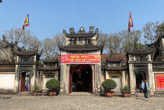
Bac Cung Temple
Bac Cung Temple (literally known as Thinh Temple) in Tam Hong commune, Yen Lac district is one of four large temples around the Ba Vi mountain region and the Red River Delta worshiping Saint Tan Vien. The temples: Tay Cung, Nam Cung, and Dong Cung are on the other side of the Red River in Son Tay territory. These are four temples that were built and preserved relatively carefully by the people. The temple is located in the middle of fertile fields on a 10,000 square meter plot of land next to winding canals, surrounded by rich and densely populated villages. On both sides, the left desert and the right desert stand majestically and silently, covering a large brick yard, looking up to a unique architectural work. Thinh Temple was built 20 centuries ago on the foundation of a small temple worshiping Saint Tan, where he had previously let his troops stay during a mission to help people clear land and manage water. The divine genealogy passes down that: Saint Tan (still called Son Tinh), whose name is Nguyen Tuan, was born on January 15, Dinh Hoi year in Lang Xuong cave, Trung Nghia commune, Thanh Thuy district, Phu Tho province. He lost his father at a young age and lived with his mother and two cousins, Nhuy Hien and Nguyen Sung. Every day, the three brothers crossed the Da River and went to the Ba Vi mountains to clear fields and farm, looking for a living. Here, Nguyen Tuan met Princess Thuong Ngan, was adopted by her, and gave her a walking stick and many magic spells to save humanity. After defeating Thuy Tinh and marrying Princess Ngoc Hoa, he refused the throne that King Hung wanted to give him, and with his two younger siblings traveled everywhere, helping people clear land and water, and was respected by people everywhere. When passing through the Tam Hong area, he let the troops rest and taught the people to grow rice and fish... After he left, the villagers came to the place where the Holy One rested and saw that there were still some packets of hearing left there, so after This temple is called Thinh temple. There is also a story that: when letting the army stay here, Saint Tan taught the people to butcher Thinh, so the people called the temple that name. From a small temple, during the reign of King Ly Than Tong (1072-1128), the temple was rebuilt into a large temple. This is where the king came to pray for longevity. During the reign of King Minh Mang (1820-1840), the temple was repaired many times. During the reign of King Thanh Thai, the Tri of Yen Lac district appointed monk Thanh At to restore the temple. The project lasted until the 6th reign of Khai Dinh (1900-1921). Through many ups and downs, the temple continues to be preserved and preserved by local people. On January 21, 1992, the temple was recognized by the Ministry of Culture and Information as a cultural and historical relic. Every year, the Thinh Temple festival is held from the 6th of the first lunar month to the 20th of the first lunar month. The festival includes sacrifices, palanquin processions from villages inside and outside the commune and many folk games will be held. Source: Vinh Phuc province electronic information portal
Phu Tho
9691 view
Rating : National monument
Bao An Pagoda
Bao An Pagoda, the full name in ancient documents is Bao An Thien Tu or Tu Gia Bao An, the popular name is Cam Pagoda, formerly belonging to Thap Mieu commune, Bach Tru canton, Yen Lang district, Phuc Yen province, Now belongs to Trung Nhi ward, Phuc Yen city, Vinh Phuc province. The pagoda was built in the 12th century during the reign of King Ly Cao Tong (1176-1210). This is one of the few pagodas dating back to the Ly Dynasty until today. The pagoda is built on a high hill, with luxuriant trees, windy on all four sides, beautiful scenery, quiet, full of solitude, a place of meditation. In the past, this area was called Tieu Dao Mountain, and is commonly called Cam Forest, perhaps that's why the pagoda is famous as Cam Pagoda. According to inscriptions and genealogies, the pagoda has existed for a long time. In the 12th century, the crown prince, son of King Ly Cao Tong, donated more than a hundred acres of fields, two thousand francs of money to repair the pagoda, and 700 francs of merit for a banquet. worship easily. Assign martial general Nguyen to directly direct and mobilize donations to repair the pagoda. As a result, the pagoda was restored with "seven newly built closely spaced rooms, columns painted with bright flowers, bright jade colors, a high and precious palace, bright sunlight and moonlight, a splendid Buddha statue, and a poised lotus throne." , the big bell towers over the phoenix, the noble king holds the dragon, the splendor and majesty are clear...". The military general of the Nguyen family also had the merit of a thousand francs to buy more than a hundred acres of fields to donate to the pagoda for farming. In the 14th century under the reign of King Tran Anh Tong, Bao An Pagoda was given a lot of money to repair and embellish by Princess Hung Nuong. To remember his merits, like many other pagodas in the area, people built a shrine to Princess Hung Nuong in the pagoda. Having gone through the ups and downs of thousands of years of history, Bao An Pagoda is still at the old campus but has had many changes. Ancient architectural buildings such as the front hall, incense burner, upper palace, ancestral house, Hung Nuong princess shrine and mother shrine were demolished due to deterioration. Currently, the pagoda has been renovated and rebuilt on a large scale, with reinforced concrete architecture and tiled roof. The pagoda also preserves valuable relics and antiques such as: Dharma statues, altars, bronze bells, and stone stele. Among them, the most typical is the stone stele "Bao An Zen Tu Bi Bi Ky" (inscription of Bao An Pagoda's stele). Up to now, according to review, survey and statistical data, this is the only Ly Dynasty stele remaining in the province. The stele was engraved in December of the year Tri Binh Long Ung (1209) and re-engraved later, probably at the end of the 18th century, placed at Bao An pagoda. The stele was mentioned and published by many researchers in Ly Tran Poetry (Social Sciences Publishing House, H.1977) and Ly Dynasty Epitaph (VNU Publishing House, H.2010). This is the oldest stele in Vinh Phuc and one of the 18 Ly Dynasty stelae remaining in our country today. The stele is 1.4m high, 0.85m wide, 0.14m thick, placed on the back of a smooth-shelled stone turtle, its head protruding, its four-clawed feet spread out in all four directions. The stele is engraved on both sides with 50 lines including 1498 Chinese - Nom characters, sharp handwriting in the style of Ly Dynasty script, very beautiful. The content of the memoir was composed by Wei Tu Hien in a parallel, parallel, and concise writing style. At the end of the memoir is an essay written in the style of Buddhist verse. The content of the stele describes the splendid and splendid scene of Bao An Pagoda in the 12th century, recording the merits of repairing the pagoda of Prince Sam, son of King Ly Cao Tong, military generals of the Nguyen family, along with Buddhists and people there. This. According to Nguyen Huu Mui (Research on Vinh Phuc Inscriptions, 2013), although the epitaph is still full of exaggeration, the image of a Ly Dynasty pagoda is clearly shown: the pagoda was restored by just one person. , the scale of the pagoda is large, inside the pagoda there are Buddha statues and lotus flowers, outside the pagoda there are bells and openings; The pagoda owns a lot of land and has a Thich Giao Zen Association (a type of Buddhist association, offering temple protection) to manage the meditation area. Based on this stele, it can be seen that the construction and restoration of pagodas took place on Vinh Phuc land since the Ly dynasty. The construction and restoration of pagodas was encouraged, not prohibited, by the royal court and assigned to the mandarins and aristocracy to preside and organize. The construction and restoration of pagodas is also considered an important event in the spiritual life of the people, attracting the whole region and even the whole country to join in the merit. This proves that during the peak development of Buddhism during the Ly Dynasty, Vinh Phuc area was also a popular center of this religion. The special thing is that among the nearly 1,500 words on the stele, there are mixed Nom words, these Nom words are used to write people's names and land names. It is said that this is one of the oldest evidences of Nom script found in Vietnam. Before this stele, traces of a few Nom characters were only found in two places: on the bell of Van Ban pagoda, Hai Phong (year 1076), and in an inscription at the pagoda of Huong Non commune, Tam Nong district, Phu Tho province. (year 1173). Bao An Pagoda was ranked as a provincial historical-cultural relic in 1995. In the period 2021 - 2025, Vinh Phuc province plans to build a scientific dossier to request recognition of the National Treasure for the pagoda steles. Bao An and upgrading the national monument ranking for Bao An Pagoda relics, these are activities to further strengthen the management, conservation and promotion of heritage values. Source: Bao An Pagoda Vinh Phuc
Phu Tho
9233 view
Rating : Provincial level relics
Tran Nguyen Han Temple
Tran Nguyen Han Temple, also known as Ta Tuong Temple or Thuong Temple, is an artistic architectural work built in the Later Le Dynasty over 200 years ago. This relic is associated with the life and career of national hero Tran Nguyen Han. He was originally from the royal family of the Tran Dynasty and was a talented and virtuous general who made great contributions to helping Le Loi defeat the Ming invaders and win the Lam Son uprising. The temple is in Da Cai village, Son Dong commune, Lap Thach district. The temple worships General Tran Nguyen Han, who supported Le Loi in defeating the Ming invaders to liberate the country in the 15th century. The temple was built on a flat, wide and high ground, and is said to be the place where Tran Nguyen Han's old palace was located. The temple is structured in the style of the letter "Dinh", surrounded by walls forming a square "dien" campus. The construction works consist of 3 parts: Temple gate, pre-sacrificial house, and harem. Since its construction, the temple has been repaired and built many times, mainly during the Nguyen Dynasty. Architectural art in the style of the Nguyen Dynasty: Smooth, chiseled, simple decoration. Related to the relic, legend has it that there are two ancient objects: the Sword and the sword sharpening stone. The story goes that: During the period when the Ming invaders dominated our country, Tran Nguyen Han had just entered his youth. Because his parents went to reclaim land and set up camp at the top of Son Dong farm, Tran Nguyen Han still plowed and hoeed every day. While plowing in the Go Rach fields, Tran Nguyen Han plowed an iron bar as long as a sword. At night, he sharpened his sword on a large stone on the bank of Son pond, so that stone was called the sword sharpening stone. The stone had a dent that looked like a slash mark. Legend has it that it was the test cut of Tran's sword. Nguyen Han. The sword was carried by Tran Nguyen Han. By chance, Tran Nguyen Han was given a wooden stick shaped like a sword hilt from the riverbed by a raft owner at the mouth of the Phu Hau River. When the blade was inserted, it fit perfectly. That's the effect. That legendary sword was associated with the glorious victories of the first national founder of the Le Dynasty. Legend has it that Ton That Thuyet later borrowed that sword and took it to Can Vuong to fight against the French. As for the stone slab, after a long time being filled with silt from the Lo River, on January 12, 1998, people of Da Cai village found it at a depth of 2m leaning towards the lotus pond, about 2.49m long, about 1 meter wide. .6m, about 0.4m thick and weighs about 2 tons. This fairy stone was salvaged by the government and people of Son Dong commune and placed in the grounds of the Ta Tuong Quoc temple so that everyone can admire the remaining traces of the old hero. In 1984, the Ministry of Culture ranked the historical relic temple of Left General Tran Nguyen Han as a National Monument. Every year, on the anniversaries of his birth and death, especially at the beginning of Spring, people in the region and all over the country often come here to offer incense to commemorate the contributions of the National Hero. Source: Vinh Phuc Electronic Newspaper
Phu Tho
8673 view
Rating : National monument
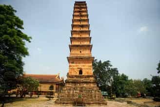
Binh Son Tower
Binh Son Tower (Then Tower, Then Pagoda Tower, Vinh Khanh Pagoda Tower) is located in Tam Son town, Song Lo district, Vinh Phuc province; is a Buddhist architecture bearing the mark of a rather long period (approximately from the 14th to 16th centuries). Binh Son Tower - Vinh Khanh Pagoda is located on a high and spacious mound, the area of the protected area is 17,200m2, including: Binh Son Tower, old Tam Bao building, new Tam Bao, ink well, house Guesthouse, lotus pond, gate, auxiliary works. 1. Binh Son Tower The tower is currently 16.5 meters high, (only 11 floors and 1 pedestal remain because the top of the tower was broken), and is constructed with a square plan that gradually gets smaller towards the top, with the side of the bottom floor being 4. 45 meters, the side of the 11th floor is 1.55 meters. The entire tower is built of unglazed fired bricks. From the base of the tower to the end of the 2nd floor, it is less than 6 meters high with the most complete pattern. On these two floors, there are carefully decorated motifs with rows of chrysanthemums, lotus petals, leaves, smooth-faced flowers, embossed dragons, and the "whispering lion" motif... From the third floor up, the decoration is still the same. However, the higher you go, the narrower the width of the tower's face is, and the decorations also gradually decrease. 2. The old Tam Bao Palace: was majorly restored in 1976, in the shape of the letter Dinh, with an area of 131.5 m2, including 5 rooms for the front hall and 3 rooms for the harem. In particular, the building has 2 bronze pillars in front, stretching out 6m, forming like the arms of a throne. The system of worship statues here is mainly made of painted soil, dating from the late 19th and early 20th centuries, with a few statues dating to the 20th century. 3. New Three Jewels: built in 2012, on the foundation of the old Three Jewels house, the architectural form is Zen monastery style. 4. Ink Well: Legend has it that this location was once the base of an ancient blue tower. When this ancient tower disappeared, it left behind a deep round well-shaped hole. 5. Guest house: newly built in 2012, area 283.5m2 with square floor plan, curved roof architecture, consistent with traditional ancient architecture. 6. Lotus pond: located in the garden in front of Binh Son tower, currently growing lotus 7. Gate to the relic site: consists of 4 brick pillars, attached with 2 iron gates in the middle, two side paths are temporarily fenced with trees and bamboo as protection gates. 8. Some decorations of Binh Son Tower Lion whinnying: One of the projects that has puzzled researchers is the "lion whinnying", because it is very different from the "jewel-catching crocodiles" wearing lotus crowns on Buddhist pedestals during the Ly Dynasty. Dragon: has horns, curls in a "nest", head turns to the center of the circle, body does not curl but forms a sinusoidal shape, so does not "tie the bag", legs kick out, or cross over the body to kick out, The spine has a "saw-tooth" shape, one front leg is raised to grasp the "hair"... Some of the details just mentioned are reminiscent of the dragons of the late Tran, but other details do not allow the dragon to be attributed to the Binh Tower. Paint in a certain pattern at all. What's more important is that Binh Son dragons often put their front legs up to grab their hair, in a funny, very mischievous pose, thus quite "folk": in this case, it has taken on the style of the dragon motif. stroking the beard in the post-Le period. The card: is a relatively popular type, with motifs that contain many meanings. Binh Son's "leaves" belong to many styles, but all styles are simple and not as elaborate as the "leaves" of the Ly Dynasty. String chrysanthemum: has been around since the Ly Dynasty in the form of a round frame, the inside of the frame neatly accommodates other decorative projects. The Tran Dynasty inherited that circular layout. Three-pronged (mountain) fighting: an interesting point is that this fighting has appeared since the Ly dynasty (Thap Chuong Son, Nam Dinh) and was even more popular under the Mac dynasty (Ty Dang Communal House, Ba Vi, Hanoi). ). Binh Son Tower has many unique features in terms of architecture, art, and construction techniques. Binh Son Tower not only has artistic architectural value, but also has high aesthetic value, called "The pearl of the national treasure", on the bricks there are many types of decorative patterns, places The shape is circular, some are circular, some are deep, some are shallow, some are dark... proving that the craftsman's hands are extremely skilled. Binh Son Tower is a work with unique architecture. According to the French, this is the most beautiful tower in Tonkin. Currently, the Festival at Binh Son Tower Relic - Vinh Khanh Pagoda is organized by the locality on January 15 every year, called "Pagoda Festival", including rituals: palanquin procession, prayer ceremony. for good weather and wind, a safe and peaceful country and cultural and artistic programs, sports, folk games (Chinese chess, human chess, cockfighting...) Binh Son Tower (Song Lo district, Vinh Phuc province) was ranked by the Prime Minister as a special national monument on December 23, 2015. Source: Department of Cultural Heritage
Phu Tho
8537 view
Rating : Special national monument
Hoa Duong Pagoda
Hoa Duong Pagoda is in Tuan Lo commune, Tuan Lo district, Bach Hac district, Tam Doi district, Son Tay town. Now it is Thuong village, Tuan Chinh commune, Vinh Tuong district. The pagoda was built in the first year of Chinh Hoa (Canh Than 1680), during the reign of King Le Hy Tong Duy Hiep. Hoa Duong Pagoda was built in the Later Le Dynasty, in 1680. What remains today is a relic with quite massive and magnificent architecture, with a "cong" shaped floor plan consisting of 3 main buildings: Front Street (7 compartments). ), the upper palace (4 compartments) and the ancestral house (5 compartments), total area of 262m2 with 2 corridors including 20 compartments with an area of 196m2, in front of the yard is a hundred year old Bodhi tree and tree species: Dai, Ngau, Lan, and Crocodile create a solemn, somber atmosphere at the meditation door. Architecturally: The structure of the rafters is in the style of "stacking beams and gongs", the load-bearing column system is all made of large ironwood, the column circumference is 1.5m and is placed on square stone bases, each 75cm big to Anti-termite and anti-moisture. Regarding fine arts: The outstanding value of Hoa Duong Pagoda is the art of sculpture, expressed in the system of round statues and wooden sculptures (y subjects, shelf paintings, horizontal panels, parallel sentences). These are the basic classes of statues, generally representing the system of statues arranged in a Buddhist temple according to the Mahayana sect in Northern Vietnam, including the following classes: Set of statues of the Three Buddhas, Amitabha Buddha, Three Buddhas, Sakyamuni Buddha, Four Bodhisattvas, Four Heavenly Kings, Statues of Monsignors, Saints, Dharma Protectors and Patriarch Buddha statues. All Buddha statues are made from old, intact jackfruit wood, with elaborate, meticulous techniques, creative and skillful art, demonstrating high artistic aesthetic thinking ability and perfect harmony in perception. the absolute "emptiness" value of Buddha Dharma. The values of truth, goodness, and beauty of Buddhism originate from the simple truths of everyday life through thousands of years of cultivation, fostering, and transmission, and have become a fundamental part of the Vietnamese soul. The soul of the artist when giving life to statues made of wood, stone, or soil becomes shimmering, fanciful but very real for each person when entering the temple to worship Buddha. The wood sculptures include: 8 paintings of y mon (horizontal sea) all of the same size (3.0m long, 0.6m wide) embossed, lacquered and gilded with natural themes: flowers, leaves, clouds, Ancient trees, birds and animals are extremely close, natural and lively, in the middle are carved "great characters" with the meaning of praise and teaching, interwoven between Buddhism and Confucian philosophy. The 8 "Shelf paintings" engraved with verses in Chinese characters with content about natural landscapes and topics related to the propagation of Buddhism, are excellent poems embedded in talented sculptures, on The background of carving techniques, liberal decoration, harmonious layout, and beautiful painting is worthy of being a legacy for future generations to admire and reflect on. 8 sets of horizontal panels, parallel sentences lacquered with gold, precise and neat sentences, profound meaning, comprehensive semantics, sincere heart, true goodness. Along with ancient relics: bronze bells, incense sticks, stone stele, etc. are also ancient written documents on stone that will be preserved forever for future generations, tourists from all over, Buddhist monks and nuns to find opportunities to admire. worshiping in the quiet meditation scene hidden in the countryside. Hoa Duong Pagoda has a history of over 300 years old. The pagoda was ranked as a national historical relic on December 12, 1994. Source: Vinh Phuc electronic communication portal
Phu Tho
8351 view
Rating : National monument
Nearby tourist attractions
See all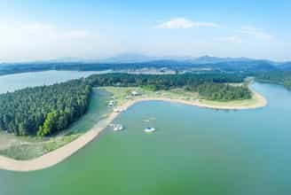
Ho Dai Lai
To go to Dai Lai tourist area, you should go in the summer, from April to September. This is the right time to go to avoid the heat, Dai Lai will have beautiful sunshine during the day and will be chilly at night. At night, the air is always air-conditioned because there are many green forests surrounding it, extremely suitable for fun activities here such as boat racing, duck riding, and yachting around the lake. Dai Lai is about 60km from Hanoi so it is quite easy and convenient to get here by car or motorbike. If departing from Hanoi, you follow Highway 2, after passing the Thang Long-Noi Bai ticket checkpoint, turn left at the first intersection, turn right at the Xuan Hoa leg and then go straight for about 10km. is to arrive. Because the distance is not far, you can go by motorbike, but you need to pay attention on the way to ensure your safety. Dai Lai Lake is 525 hectares wide, surrounded by a vast green forest of protective trees. From the beach under the lake, you can go to the top of Than Lan mountain in the south to admire the scenery from above, far away is the magical Tam Dao mountain range. Besides, visitors can visit the villages of the San Diu people to discover more about customs and enjoy extremely unique and interesting ethnic dishes. Pearl Island, also known as Bird Island, located in the middle of Dai Lai Lake is a gathering place for hundreds of different species of birds flying from all over, making this place like a vivid natural picture. which is rarely found anywhere else. Coming to Dai Lai, you can participate in many interesting outdoor activities such as swimming in the lake, duck riding, taking a boat to visit the islands around Dai Lai lake, admiring the scenery, taking photos and visiting the green mountains and forests. cool. You will have unforgettable experiences when splashing in the cool water or leisurely pedaling ducks while admiring the scenery. Because Dai Lai Vinh Phuc tourism has recently developed a lot, many motels have also sprung up. Finding a place to stay overnight with good service and reasonable prices is not too difficult, however you should book in advance because it is easy to run out of rooms. Especially recently, the Flamingo Dai Lai resort is also popular with many people because of the combination of natural scenery and human-created architecture. In addition to delicious food, there are also extremely attractive services and games. You can enjoy everything according to 5-star hotel standards and more: swimming pool, billiards, tennis, golf course, boat, garden... however the price is also quite high compared to other places to stay.
Phu Tho
8772 view
From January to December
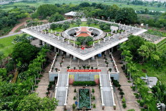
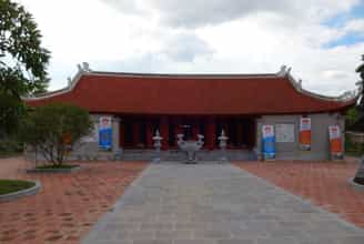
Hung Temple relic area
Hung Temple is a place of worship for 18 generations of Hung Kings and the king's royal family, those who contributed to building the country and are considered the Ancestors of the Vietnamese people. In the past, this land was the capital of Van Lang country, surrounded by two rivers and rolling mountains. That terrain has caused this place to have many rivers, lakes, mountains, hills and fertile alluvium, creating favorable conditions for people to settle down and at the same time easily defend or retreat in case of conflict. According to scientific documents, the Hung Temple complex began to be built on Hung Mountain during the reign of King Dinh Tien Hoang (968 - 979). Then, around the 15th century, under the Later Le dynasty, the entire relic area was completely built to the current scale. Hung Temple has a total area of 845 hectares with 4 temples, 1 pagoda, 1 mausoleum and many other architectural items, distributed from the foot of the mountain to the top of the mountain, in harmony with the overall majestic landscape. Over time, many relics in the Hung Temple complex have been embellished and supplemented but still retain their ancient and solemn features. For thousands of years, Hung Phu Tho Temple has been a solemn, respectful symbol, closely associated with the cultural and religious life of the nation. Hung King's death anniversary is held on the 10th day of the third lunar month every year and has entered the subconscious of every Vietnamese person with the folk song "No matter who goes back and forth - Remember the death anniversary on the tenth day of the third month". Every year on this day, millions of Vietnamese people from all generations of "Dragons and Fairies" eagerly return to their ancestral land to offer incense at Hung Temple to express their gratitude to their Ancestors, remember their national roots and pray for peace, health and good things. With special historical, cultural and scientific value, Hung Temple is ranked as a special national relic according to Decision No. 1272/QD-TTg, dated August 12, 2009 of the Prime Minister. It can be said that Hung Temple is a convergence of profound spiritual cultural values of the Vietnamese ethnic community throughout history. This is expressed very specifically and vividly through the worship of Hung Kings and the Hung Temple festival. Hung Temple Festival is a major festival in Vietnam of national stature, attracting the attention of all Vietnamese people with the blood of "Dragon and Fairy", whether living in the country or abroad. Since 2012, the worship of Hung Kings has officially been recognized by UNESCO as an Intangible Cultural Heritage of Humanity thanks to its unique and distinct values. This is an important milestone and a great honor not only for the people of the Fatherland but also for the entire nation.
Phu Tho
10444 view
February to April
Au Co National Mother Temple
Since ancient times, Mother Goddess worship has become a typical beauty in Vietnamese culture. Many historians believe that this custom comes from the land of Hien Luong (Ha Hoa district, Phu Tho province), where the Au Co Ancestor Temple is located. Under the lush foliage of the ancient banyan tree, countless generations of Lac Hong's descendants have offered incense to pay their respects to Mother Au Co and told each other the legend of the nation's great mother. Legend has it that, the day Au Co was born in Lang Xuong cave (now in Thanh Thuy district, Phu Tho province), there was auspicious clouds protecting her, and a fragrant fragrance spread throughout the space. Growing up, she was beautiful, smarter than most people, read carefully, was good at playing the flute, and was proficient in phonics. After marrying Lac Long Quan - son of Kinh Duong Vuong, Au Co gave birth to a sac of eggs, which hatched into one hundred children. One day, seeing that his children had grown up, Lac Long Quan said to Au Co's mother: "I am a Dragon, you are a Fairy. Although yin and yang come together to form a hundred children, it is difficult to unite because of the different lineages." copper". Having finished speaking, Lac Long Quan led 50 children into the sea. Au Co's mother took her 50 children to the mountains, wherever they went, they conquered people's hearts and cleared the wild forests. One day, passing through Hien Luong, where there were high mountains, wide fields, and long rivers, Mother immediately cleared the land and taught people to cultivate rice, grow mulberries, raise silkworms, and weave cloth. When the farm was beautiful, Mother hurried to a new land. Later, Au Co's mother returned to Hien Luong, remaining attached to this place for the rest of her life. On the 25th day of the twelfth month of the year Nham Than, Au Co's mother flew to heaven, leaving a silk bib under the banyan tree. There, the people built a temple to worship and forever commemorate the National Mother. Au Co Ancestor Temple was officially built during the reign of King Le Thanh Tong (1442 - 1497). The legend of the temple records that the temple is hidden under an ancient banyan tree, facing south, on the left is Loan well, on the right is Phuong well, in front is Giac mountain as beautiful as a script, behind is Giac mountain. The Red River meanders like a sacred dragon surrounding it. Over more than five centuries, the Mother Temple has seriously degraded. In 1998, the Party Committee and people of Hien Luong restored the temple. The temple is not large or massive, but it is highly appreciated for its art. Visitors can find here many relics such as the statue of Au Co, the statue of Monsignor Cao Son, or delicate carvings on the hammock doors, crossbeams, and friezes around the upper palace door. Currently, the main temple has a Dinh-style layout with three harem rooms and five grand worship rooms. Mau Au Co Temple combined with Linh Phuc Pagoda creates a relic complex that has a special attraction for tourists from all over. Ms. Nguyen Thi Tuyet Mai, Head of the Management Board of Au Co Mau Mau Temple Relic Area, said: "With the consent of the government, we are quickly restoring the temple to worship Monsignor Dot Cao Son (the second son of Mau Temple) is located 500m east of Mau Temple to meet the sightseeing and religious needs of the people.
Phu Tho
7766 view
February to May
Wow
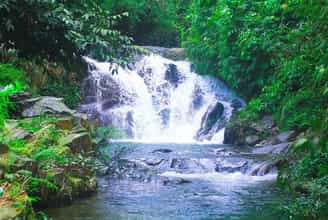
8km from Au Co Mau Temple, Ao Gioi - Suoi Tien tourist destination is located on Na mountain in Quan Khe commune, Ha Hoa district. This is a tourist destination with wild beauty, fresh and cool air, suitable for tourists who love to explore. According to legend, on the morning of January 7, Mother Au Co went west to No mountain, later called Na mountain, and encountered a rock crevice. She went up the cliff and met a group of fairies who brought down dresses for her. Replace and welcome Mother to heaven according to the Jade Emperor's orders. The water where Mother bathed flowed down to the foot of the mountain, forming a stream, later generations called it Ao Gioi - Suoi Tien and anyone who bathed in Ao Gioi - Suoi Tien for 3 years would have smooth white skin like pearls and a bright face. beautiful like the full moon. The road to Ao Gioi - Suoi Tien has many large and small mountain peaks on both sides, in which Mount Na towers higher than the surrounding mountains. Visitors can take two main routes to visit Ao Gioi, Gieng But, Vuc Xanh, Tien Cave, Bottomless Cave, Ban Che Waterfall, and Canh Tien. Fairy Stream originates from Na mountain, flows through rock crevices like a silver-white silk strip, across the mountainside, standing out among the smooth green of the mountains and forests mixed with the blue of the clouds and sky, creating a poetic scene. just close. Water flows from Na mountain through many waterfalls into a clear stream. The stream bed is thick with gravel and yellow sand, making the stream water pure, clear, and sparkling with reflected sunlight. At the source of the stream is Fairy Well. From the bottom of the well, cool and sweet water sprays out to form Fairy Stream. Fairy Stream winds through many levels and steps, creating many vertical waterfalls. Along the length of the stream, there are many waterfalls, some 20m high, white foam day and night, including Ban Co and Canh Tien waterfalls are the most beautiful waterfalls. Both sides of the stream are covered with a dense green color of tropical plants, crowded together in layers and layers. The wild scenery and fresh air create a rich flora and fauna system in Ao Gioi and Suoi Tien. At the foot of the high waterfalls are giant stone slabs that, over a long period of time, have eroded into small ponds whose bottom is a whole slab of stone, creating a unique beauty here. Ao Gioi - Suoi Tien is still pristine, has abundant tourism potential, can develop all types of climbing, camping, relaxation and scientific research because the flora here is very diverse and rich. rich. Currently, the road to this tourist destination has been paved, making it convenient for visitors to have interesting experiences here.
Phu Tho
7802 view
March to November
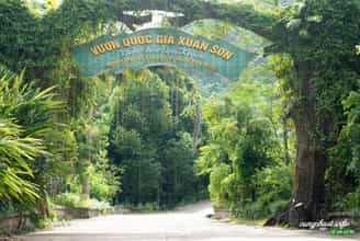
Xuan Son National Park
According to experience traveling to Xuan Son National Park, traveling here at any time is reasonable because each season has different beauty. In the dry season, the road is easier to travel, can limit more risks, the scenery is fresher and more convenient for going out. But in the rainy season, although the road to Xuan Son National Park may be a bit difficult, visitors will admire the rare, majestic and powerful murmuring waterfall. Depending on each person's needs, the amount of items they carry may vary. Because there are not many grocery stores or places providing consumer services near this tourist destination, visitors must proactively bring clothes, personal items, food (candy, instant noodles, milk...), shoes..etc... If you are more careful, bring a spare battery charger for your phone or camera. When coming to Xuan Son National Park, first, we must mention: Hang Na, Hang Lang, Hang Lun, Thien Nga Cave, Tho Than Cave with many wild, cool and beautiful scenes, close to humans but not Less magical and mysterious. Next, visit the villages in Xuan Son National Park to learn about the culture, primitive and simple life, and unique customs of the people here. Join them to experience daily tasks such as knitting utensils, weaving brocade or fermenting wine, fishing in streams near the village, etc., ensuring that these activities will be no less attractive. interesting. After that, take a walk around the market. Many ethnic items are sold in the market so you can freely choose meaningful items as gifts for friends, relatives or to use for your own needs. me. If you go home during the day, you can proactively eat and drink and bring your own fast food. Otherwise, you have to move to Tan Son town or Viet Tri city to enjoy delicious dishes in Phu Tho. Some suggested dishes are: Phu Tho sour meat, Phu Tho dog meat, cassava vegetable soup stewed with pig's feet...etc. Prices at eateries and restaurants in Phu Tho are very affordable, with absolutely no cutting corners for profit.
Phu Tho
7530 view
March to August