


List of relic sites (45)
Datanla waterfall relic area
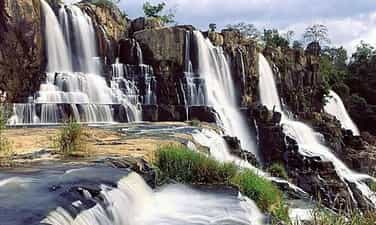
National historical and cultural relic tourist area Da tang la waterfall, also known as Da tan la, is a famous waterfall in Da Lat city, Lam Dong province, Vietnam. Located in the Da Tan La tourist area, the waterfall is 8 km from Prenn waterfall and about 10 km from Da Lat city center. Da Tang La Waterfall is considered one of the ideal destinations for tourists who want to visit and experience adventure. The name "Da tang la" or "Da tang la" is taken from the K'Ho language, made up of the word "Da-Tam-N'ha", meaning "there is water under the leaves". This name originates from the historical conflict between the Cham - Lach - Chil peoples in the 15th century. to the 17th century. Da Tang La Waterfall has abundant water thanks to a stable water source from upstream. Not as noisy as some other waterfalls, Da Tang La flows through many stone shelves and falls from rapids about 20m high. The lower part of the waterfall forms a very clear water area, called Suoi Tien, while the upper part has a deep pool called the Death Abyss. According to legend, because this abyss is located in the middle of a mountainous area, it was once a refuge for an army of the indigenous people during the war with the Cham people hundreds of years ago. There are many legends about the origin and meaning of Da Tang La waterfall. One of them tells about the meeting of the brave warrior K'Lang and the mountain girl Hobilang here. Some other legends about Da Tang La waterfall say that the waterfall is the place where fairies often bathe, or the story about the war between the Lat and Cham people, in which the waterfall played an important role in the fighting strategy of the people. Surname. With those cultural values, in 1998, Da Tang La Waterfall was recognized by our state as one of the famous landscapes and historical relics in Da Lat, ranked as a national monument. . Source: Da Lat tourism information portal
Lam Dong
4836 view
Rating : National monument
Historical relic of Cam Ly Waterfall in Dalat
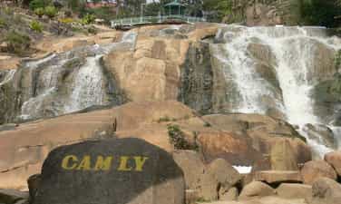
Cam Ly Waterfall is located 2km west of Da Lat city. This is considered the waterfall located closest to the city center. Cam Ly waterfall is located next to Cam Le stream, the waterfall is formed from part of the water flowing in from Xuan Huong lake and another stream, Cam Ly stream, also flows here. Cam Ly Waterfall is one of the waterfalls that talks about the remembrance, gratitude, and respect of the people here for people with meritorious services during that period. Legend has it that Cam Ly waterfall originated from the K'Ho language. People in the Lach (Lat) tribe call Cam Ly waterfall Lieng To Sra - the boundary of Cam Le stream to Da Dong river. People in the new village took the name of the chief of the Lach (Lat) tribe at that time, K'Mly, to commemorate and show the villagers' gratitude to this chief. This chief took care of the meals and sleep of the entire tribe, lived in harmony with the people, and took care that the lives of the people in the village became prosperous, prosperous, and complete. So the name of this chief given to the waterfall was K'MLy, later pronounced Cam Ly. According to the Sino-Vietnamese origin, Cam Ly means stream with fresh water (Cam means sweet, Ly means permeable). Cam Ly Waterfall possesses poetic beauty, especially in the rainy season when the water flows rapidly, creating huge blocks of water pouring down violently. With a convenient location near the city center, Cam Ly waterfall attracts a large number of tourists every year. At the foot of Cam Ly waterfall is a small flower garden, contributing to creating a harmonious and beautiful landscape. In addition, in the waterfall area there is also Nguyen Huu Hao mausoleum, built with many unique architecture. In 1998, Cam Ly Waterfall was ranked by our state as a scenic spot and historical relic in Da Lat, recognized as a national monument. Source: Da Lat tourism information portal
Lam Dong
4846 view
Rating : National monument
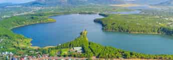
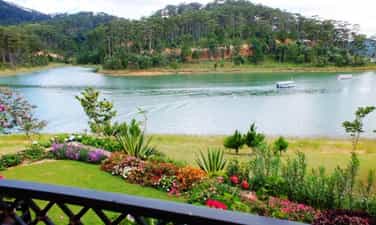
Xuan Huong Lake Relics
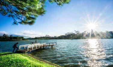
When mentioning Da Lat, no one knows about Xuan Huong Lake, a beautiful lake located right in the center of Da Lat city. Xuan Huong Lake is an artificial lake, with a circumference of about 5km and 25ha wide. The lake has the shape of a crescent moon, stretching more than 2 km and passing through many famous tourist attractions of Da Lat such as the City Flower Garden, Yersin Park, Cu Hill and Lam Vien Square. According to people here, the origin of the name Ho Xuan Huong comes from two different legends. The first legend says that every spring, there is a faint, fragrant scent around the lake, ecstatic. That's why people gave the lake the name Xuan Huong Lake. However, the second legend says that Ho Xuan Huong was named after a 19th century Vietnamese female poet named Ho Xuan Huong. Ho Xuan Huong is the author of a number of famous poems such as Floating Water Cake, Life as a Monk, Debt to Husband and Children,... Xuan Huong Lake was originally a large valley, and Cam Ly stream flowed through. In 1919, engineer Labbe blocked this stream so that water could accumulate and form a lake. Then, in 1923, French engineers built a dam at the bottom of the lake, but it broke after a storm in 1932. Engineer Tran Dang Khoa then rebuilt a new dam. made of stone. In 1989, Xuan Huong Lake was recognized by our state as one of the famous landscapes and historical relics in Da Lat, ranked as a national monument. Source: Da Lat tourism information portal
Lam Dong
5469 view
Rating : National monument

Tuyen Lam Lake Relic in Da Lat
Tuyen Lam Lake was formed in 1985 - 1986. At that time, the People's Committee of Lam Dong province and Duc Trong district deployed troops to build dams to retain water in the Suoi Tia area. Surrounding the Suoi Tia flow area are surrounding mountain ranges that form a basin. When the dam is built to retain the water, it forms Tuyen Lam Lake as it is today. Initially, the main purpose of Tuyen Lam Lake was to store water for main use for irrigation in agricultural production in the downstream area - Hiep An and Dinh An communes in Duc Trong district of Lam Dong province. By 1998, when Tuyen Lam Lake was recognized by the Ministry of Culture, Sports and Tourism as a national historical and scenic site on August 31, 1998, the Tuyen Lam Lake area received even more attention and attention. Not only does it serve irrigation purposes in agricultural production, but it is also used by agencies from central to local levels to guide tourism development planning. Tuyen Lam Lake has an area of 350 hectares; More than 6km south of Da Lat city center. Tuyen Lam Lake area has a fresh climate, quiet space, natural landscapes (forests, mountains, lakes, streams, waterfalls,...) that are diverse, attractive and have many attractive and promising humanistic elements. become a large-scale tourist area with many unique types of tourism such as: sightseeing, camping, relaxation, medical treatment, walking, climbing, fishing, festivals - beliefs, entertainment entertainment, sports,...especially eco-tourism. During the two resistance wars against the French and American invaders, with the location and topography of the Suoi Tia area (now Tuyen Lam Lake) and Elephant Mountain, it was the most important base of the revolutionary movement in Da Lat city and Da Lat city. Tuyen Duc province. This base area serves as a place to direct political and armed struggle movements of the army and people of Da Lat town and Tuyen Duc province, and a place to gather and train the armed forces. , the working teams of the Province and the military region, are the springboard for forces to attack Da Lat and maneuver to fight the enemy on fronts in Tuyen Duc province. During the resistance war against the Americans, in addition to the City Party Committee, there were also military units stationed such as the Financial Department, the clinic, the Women's Work Team, the Youth and Students, the Urban Work Team, and the City Special Forces 850 and 852. , 860... and leading agencies and front units of the province such as the Provincial Party Committee, Provincial Team, logistics, Corridor Station, Company 810 (later to become Battalion 810), Provincial Security Team and forces of the Region 6 as Battalions 186, 145, 200C. From 1982 to 1987, Lam Dong Irrigation Company, invested by the Ministry of Irrigation, built a 235m long dam across Tia stream to create Quang Trung lake, later renamed Tuyen Lam lake. By 2017, the Prime Minister recognized Tuyen Lam Lake National Tourist Area, Da Lat City, Lam Dong Province as a National Tourist Area. Tuyen Lam Lake National Tourist Area was honored by UNESCO as "Typical Asia-Pacific Tourist Area" in the Forum Program "Vietnam - India Cultural and Economic Exchange". Tuyen Lam Lake National Tourist Area has rich tourism resources including natural landscapes, forest resources, climate, cultural and architectural values; Invested and renovated infrastructure along with ongoing investment projects have been promoting value, contributing to affirming the position of Tuyen Lam Lake National Tourist Area on Vietnam's tourism map. South with diverse types of tourism. Source: Management Board of Tuyen Lam Lake National Tourist Area
Lam Dong
5114 view
Rating : National monument
Historical site in Da Lat - Than Tho Lake
Than Tho Lake is located about 6 km east of Da Lat city center, near Da Lat National Martial Arts School (currently the Army Academy). The lake is located on a high hill in the middle of a pine forest, providing a peaceful and quiet space. On the north side of the lake there is a pair of pine trees that evoke the image of a couple, near the scenic Pine Hill Two Tombs with the legend of a broken love. Initially, the Than Tho lake area was just a small pond, and was called Tono Pang Dong. However, in 1917, the French built a lake here to provide daily water for Da Lat. The French named the lake Lac Des Soupirs (meaning "murmuring lake" in French). However, later, the lake was renamed Than Tho Lake by Mr. Nguyen Vy, Chairman of Da Lat Town Council, to express sympathy for the legend of the romantic love story between Hoang Tung and Mai relying on the year of the 18th century here. Than Tho Lake has experienced many ups and downs in history. From the reclamation of mountains and forests in the 1980s - 1990s, to the process of conservation and restoration at the end of 1990. In 1999, Than Tho Lake was recognized and ranked by our state as a scenic spot, national historical relics. Source: Da Lat tourism information portal
Lam Dong
4951 view
Rating : National monument
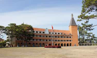
Da Lat Pedagogical College
Da Lat Pedagogical College was established on September 3, 1976 by decision of the Ministry of Education. The school was assigned by the Ministry of Education to become a secondary school teacher training center for Lam Dong province as well as some neighboring provinces. Initially, the school was called Grand Lycée Yersin, built by the French in 1927 for French citizens and some wealthy families to study. The school's main building is designed and built in a unique style and has been recognized by the World Association of Architects. After the victory of the Ho Chi Minh campaign on April 30, 1975, the school was reclaimed by the Vietnamese government and converted into Da Lat Pedagogical College. Currently, the school's buildings have been repaired and upgraded, with new roofing tiles being replaced. The school's special features lie in its 54-meter high bell tower and unique arc-shaped buildings. In 2001, Da Lat Pedagogical College was recognized by our state as one of the historical relics in Da Lat recognized as a national relic. In August 2022, Da Lat Pedagogical College was merged with Lam Dong Economic and Technical College and Da Lat Vocational College, then renamed Da Lat College according to the decision of the Ministry of Labor Movement, War Invalids and Society. Source: Da Lat tourism information portal
Lam Dong
4614 view
Rating : National monument

Dalat Railway Station
Da Lat Station is not only a unique architectural work of Da Lat city, but also a place that makes a special mark in the history of Vietnam Railways. Da Lat Station is located on Quang Trung Street (Ward 10, Da Lat City, Lam Dong Province), also the only train station in the Central Highlands region. Da Lat Station is associated with the history of formation and development of the "land of thousands of pines" urban area, considered the most beautiful ancient train station in Vietnam and Indochina. Da Lat Station was built from 1932 to 1938, located on the Thap Cham - Da Lat railway, connecting the plateau city with Phan Rang (Ninh Thuan). This railway line is 84km long, with an elevation difference of 1,500m, and was started in 1908 by order of Governor General of Indochina Paul Doumer. In 1932, the route was completed, which was also the time to build Da Lat station. The entire route has 12 stations and 5 underground tunnels. It is a special railway because it has 16km of cog railway climbing steeply, with an average slope of 12%. At that time, railways and locomotives with cog wheels only existed in Switzerland and Vietnam. In 1972, this railway line was destroyed by war. In 1975, the country was unified, this line was restored but only operated for a short time due to poor economic efficiency. The rail system and cog railway tracks were removed. The stations were abandoned. Dalat Railway Station was designed by two French architects, Moncet and Revéron, with bold indigenous architecture. The structure of the project is coherent and scientific, but the form is very sophisticated. The building has a symmetrical layout, with the architectural block in the middle simulating the three peaks of Langbiang Mountain and the roofs of the Central Highlands' communal houses; On both sides are two sprawling architectural blocks. In the middle of the building, outside, under the roof, there is a large clock face recording the time Dr. Alexan Dray Yersin discovered Da Lat. In the middle block, there are two front halls, one for passengers and one for cargo. Between these two paths is the train waiting area. This middle architectural block has only 1 floor with large space and a height up to the roof. Overall, the building's architecture is in harmony with nature and is a unique urban highlight. Da Lat Station was recognized as a national historical and cultural relic in 2001. Currently, Da Lat station has been separated from the Vietnam national railway system, but is still an attractive tourist destination. The station maintains a tourist train consisting of 1 locomotive and 4 carriages going back and forth to Trai Mat station (ward 11, Da Lat city), located in the east, 7km from Da Lat, about 25 minutes away. On this road, visitors can admire the romantic suburban landscape of the city. At the last stop is Trai Mat station, visitors can visit Linh Phuoc Pagoda (also known as Ve Chai Pagoda) - a famous and unique pagoda. In addition, Da Lat station still sells intermodal tickets on the Thong Nhat railway, departing from Nha Trang station (Khanh Hoa) and serving Da Lat - Nha Trang transit cars. Along with famous works of Da Lat such as: Cathedral, Bao Dai Palace, Da Lat Pedagogical College..., Da Lat Station is a destination not to be missed for tourists coming to the city. Da Lat. There is also an antique steam locomotive on display and a cafe located in a train car. The station's romantic scenery and ancient architecture is a place where many people come to "hunt" for beautiful photos Source: Vietnam National Tourism Administration
Lam Dong
5452 view
Rating : National monument

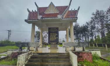
Historical relic of Bu Prang Border Guard Station area
On January 4, 2023, the Bu P'rang Border Guard Station area historical relic located in Dak Huyt and Bu P'rang 2 bon, Quang Truc commune, Tuy Duc district, Dak Nong province was recognized as a Monument. Provincial history. Martyrs' Memorial - a place to register and pay tribute to 16 officers and soldiers of the unit who heroically sacrificed their lives in the war to protect the Southwest border in 1977. To serve the task of protecting border security and sovereignty, on May 20, 1975, Bu P'rang People's Armed Police Station (predecessor of Bu P'rang Border Gate Border Guard Station) was established. with an initial force of 32 armed police officers and soldiers sent as reinforcements from Son La province. At that time, the station was assigned the task of managing and protecting national border security and sovereignty with a 16.5 km long border section, located in Quang Truc commune (Dak R'lap district, former Dak Lak province), now known as Dak Lak. Tuy Duc district (Dak Nong), bordering Mondulkiri province, Kingdom of Cambodia. During the war to protect the Southwest border, officers and soldiers stubbornly held on, courageously fought 127 battles, firmly defending every inch of the Fatherland's sacred land. The historical milestone that demonstrated the brave spirit of the soldiers at that time was the battle that lasted 47 days and nights (from March 29 to May 16, 1978) with the Pol Pot gang. The above mentioned victorious fight to protect border security and sovereignty demonstrated the solidarity, determination to fight and willingness to sacrifice of the officers and soldiers of the Bu P'rang People's Armed Police Station. . With that feat, on November 6, 1978, Bu P'ran People's Armed Police Station was honored by the State as Hero of the People's Armed Forces. Bu P'rang Border Gate Border Guard Station is stationed in Tuy Duc district, 35 km from the district center, assigned to manage and protect the 11 km border area, in charge of Bu P'rang 2 border. belongs to Quang Truc commune (Tuy Duc). With the spirit of "The station is home, the border is the homeland, people of all ethnic groups are blood brothers", the party committee and unit commanders have thoroughly grasped and seriously implemented the directives, orders and superiors' plans on tasks and border guard work. Accordingly, along with fully developing combat documents, the station regularly organizes training plans to ensure high combat readiness, proactively detect and promptly handle all situations that arise on the border. border, area, border station. In just the two years 2020-2021, the station organized 676 border patrols, controls and protections with 6,084 officers and soldiers, thereby detecting and handling 10 cases/11 border violators. gender. As a border gate station, the unit maintains strict and lawful immigration and import and export control activities through the border gate, and at the same time advises the Party Committee and local authorities to well carry out people-to-people diplomacy work. , maintain stability and develop cooperative relations on both sides of the border. Source: New Rural Information Website - Dak Nong Province
Lam Dong
4921 view
Rating : Provincial level relics

Serepok Bridge
Serepok bridge was built by the French in 1941, completed, put into use in 1957 and named bridge 14 by the French government (bridge located on route 14), while local people named it Serepok bridge because spanning the Serepok River connecting the two provinces of Dak Lak and Dak Nong. The eastern bridgehead belongs to Hoa Phu commune, Buon Ma Thuot city, Dak Lak province; The eastern bridgehead belongs to Tam Thang commune, Cu Jut district, Dak Nong province. In 1904, the French colonialists began building a governing apparatus, establishing an administrative unit of Dak Lak province and dividing the Dak Lak plateau into five districts. During the invasion, the French colonialists realized the difficulty of traveling on the vital road, affecting their intention to invade and expand their territory. In 1941, the French colonial government decided to build bridge 14 and the bridge was built with the blood of political prisoners in Buon Ma Thuot exile house and local people. The bridge is designed with a continuous reinforced concrete truss structure running underneath, 169.5 m long, 4 spans, 5 m wide, two pedestrian lanes of 1.37 m, vehicle lanes of 2, 8 m, load capacity 5 tons. In the early 40s of the 20th century, Serepok bridge was modern and had beautiful architecture. Entering the period 1954-1975, Route 14 was thoroughly exploited by the US imperialists and the puppet government, with blocking forces deployed to control and block all resources of the Vietnamese army. It was also here that our army and people launched an important offensive to liberate Buon Ma Thuot (Dak Lak) and then towards Saigon, completely liberating the South and reunifying the country. In 1985, facing the development of road transport, the Serepok bridge built during the French period could no longer meet the transport needs in terms of both load and vehicle density, so the Ministry of Transport decided to invest in Investing in the construction of a new bridge to replace the old bridge that has a small load and has deteriorated. The new Serepok bridge was built on Highway 14, 30 meters north of the old bridge. The bridge is 176 m long, has a simple beam reinforced concrete structure, includes 5 spans, 11 m wide, has 2 motor vehicle lanes 7 m wide and 2 walking lanes 1.25 m wide each. The project is invested by Road Zone 5 and constructed by Traffic Construction Company 510 of Transport Construction Corporation 5 under the Ministry of Transport. The bridge was completed and put into use in October 1992. Since then, vehicles traveling on Highway 14 have crossed the new bridge. In 2016, a third bridge between the two bridges was also completed to serve the increasing travel demand on Highway 14. With that meaning, Serepok Bridge was chosen by the People's Committee of Dak Nong province as a heritage site of Dak Nong Geopark under the "Symphony of the New Wind" tourist route. Source: Dak Nong Electronic Newspaper
Lam Dong
4901 view
Rating : National monument
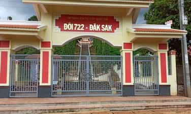
Victory location Hill 722 - Dak Sak
Hill 722 - Dak Sak is a US-Puppet commando base established in 1965. This is where a fierce battle took place between regular troops and local military forces attacking and destroying the commando base on September 19. August 22 and 23, 1968. Hill 722 is at an altitude of 722m above sea level in Tho Hoang 4 village, Dak Sak commune, Dak Mil district. In May 1965, the US - puppet government and the Saigon government built the Hill 722 military base (also known as Duc Lap special forces camp) about 10 km east of the center of Duc Lap district to strengthen their forces. volume and increased military activities. To deal with the enemy's plots and tricks, in 1968 the Politburo and Central Highlands Field Command determined it was necessary to destroy the enemy at Duc Lap district headquarters, whose core was the military base Hill 722 - Dak Sak, one of the enemy's key strongholds on the Central Highlands front. Implementing that policy, during the years 1968 to 1975, our main force coordinated with the local army and people to organize many battles at this base, on the one hand to drain the enemy's vital forces, and on the other hand to defeat the enemy. destroyed the system of posts that were sabotaging the Ho Chi Minh Trail on the Southern Central Highlands battlefield. After 1968, after many heavy defeats in the Southern Central Highlands battlefield, the enemy retreated and entrenched in military bases, in which Hill 722 - Dak Sak was an important military base. From here, they continued to implement the policy of gathering people to form hamlets. Faced with that situation, to maintain the posture, the Quang Duc Provincial Party Committee directed the Dak Mil District Party Committee, determined to overcome difficulties, implement the "three clings" (cadres cling to the people, people cling to the land and guerrillas cling to the enemy). continue to fight the enemy, promote the construction of rear bases, increase production, and ensure food supply for the front; Expand the liberated area, push the enemy into a clustered position, and prepare to fight with the people of the whole country. By 1975, Dak Sak and Duc Lap strongholds were completely wiped out by our troops. After the liberation day, to commemorate the great sacrifice of our officers and soldiers at Hill 722 - Dak Sak in particular, and in the Duc Lap campaign in the fall of 1968 in general, Dak Nong province established a memorial to them. heroic martyrs. On October 24, 2012, Hill 722 relic - Dak Sak was recognized by the Ministry of Culture, Sports and Tourism as a national historical relic. Currently, Hill 722 - Dak Sak Historical Site has a total area of nearly 4 hectares. On this site, there are still some relics and military equipment, such as shoes, hats, and bullet casings. In 2010, Area I of the monument was invested by the State to build a memorial stele house, green campus and fence with a total construction investment area of 2,485m2. Every year, the relic serves over 1,000 visitors to visit and study. This is a historical relic of great significance in traditional education, political awareness for the young generation, and gratitude for the great contributions of our ancestors. It is one of the historical milestones in the struggle for national liberation of the Party Committee and People of Dak Nong province in particular and Vietnam in general. Source: Dak Nong Electronic Newspaper
Lam Dong
4673 view
Rating : National monument
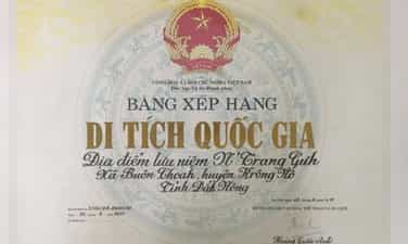
Historical relic N'Trang Guh memorial site
Based on local historical records and the accounts of some village elders in Krong No, N'Trang Guh, real name Y Guh, is an Ede ethnic person, born around 1845, in Choáh Kplang village, now in the commune. Buon Choáh (Krong No). Legend has it that N'Trang Guh was talented, virtuous and a good hunter in the village, so he had many valuable possessions such as rhino horn and ivory. Not only that, he also knows how to calculate business well, so every time the season comes, he always harvests a lot of rice and corn, raises many buffaloes, cows, pigs, chickens... and has a reputation in near and far villages, and is loved by everyone. beloved person. In addition to being rich in wealth, he is also a compassionate person because he always guides people through experiences in hunting, animal husbandry, and farming and is willing to help the poor, in need, and with crop failures. In 1884, the Siamese army waged a war of invasion, capturing the lower reaches of the Krong No and Krong Ana rivers. Responding to N'Trang Guh's call, people in 20 Bih ethnic villages living in the Krong No and Krong Ana river basins stood up against foreign invaders. The insurgent army commanded by N'Trang Guh had up to 600 people, had no guns, only used rudimentary weapons: bows, arrows, spears... In order to increase their strength, N'Trang Guh created a fairly good crossbow. special, not found anywhere else. The crossbow is longer than a person's head, the side is one hand wide, and shoots 3 arrows at a time. With this powerful weapon, combined with the spirit of courage, tenacity and cunning, in 1887, the N'Trang Guh insurgent army surrounded and destroyed the entire Siamese army right on the fields of Tur and Phok villages. The glorious victory of the N'Trang Guh insurgent army crushed the invasion of the Siamese army, helping the people feel secure in working in production and building villages. In the early years of the 20th century, the ruling apparatus of the French colonial government acquired and controlled almost all the trading and trading of indigenous people in the Central Highlands. Bourgeois, the first French envoy in Dak Lak, blatantly used military force to drive the Ede and M'nong people to other places, taking over villages, villages, land, fields, and water wharves to Establish plantations and build a system of posts. The compatriots were forced to work as laborers on French plantations, and they had to work 14 to 15 hours a day. In early 1900, the French army invaded the villages of the Bih people along the Krong No and Krong Ana river basins. N'Trang Guh led the insurgent army to fight against the invaders, the most famous being the battle to destroy the Tur garrison. One morning in 1901, under the direction of N'Trang Guh, the insurgents crossed the Krong No River to surround Tur station, used crossbows to shoot many enemy soldiers, and then attacked the station. In just a short time, all the enemy troops stationed here were destroyed. The colonialist Buoc Gioa, who had a lot of blood debt to the people, died in front of the station yard. Taking advantage of the victory, the insurgents continued to attack, one by one destroying other colonial posts such as Jiang post, Dur post... With the skillful and courageous leadership of N'Trang Guh, the insurgents fought fought for 13 years. In 1914, because there was a traitor in the ranks of the insurgent army, the location of N'Trang Guh's station was revealed, so he was arrested by the French and sentenced to death. After N'Trang Guh passed away, his body was brought back by the people to be buried in his hometown, where he was born, Choah village, Choah village (Krong No). To remember the place that left many illustrious marks of the chief of Ede village, a hero of the Central Highlands peoples, on August 2, 2011, the Ministry of Culture, Sports and Tourism ranked N'Trang Guh souvenir site is classified as a national historical site. Source: Krong No District Electronic Information Page
Lam Dong
4922 view
Rating : National monument
The historical site connects the Central Highlands to the Southeast
The historical relic of Cay Xoai village is a contact point to open the North-South strategic corridor, the section through Dak Nong province. On May 25, 1959, the Central Military Commission and the Ministry of National Defense officially established Group B90, with the mission of secretly going to the South with on-site units to build facilities and open two routes to the East and West. from the Southern Central Highlands to the Southeast region - where the Southern Party Committee is located. Overcoming difficulties, sacrifices and even unsuccessful connection trips, finally, at about 4:00 p.m., October 30, 1960, the B90 Working Group made contact with the C200 working group of the Southeast region. Ministry at Cay Xoai village, Dak Nia commune, City. Gia Nghia, Dak Nong province. On November 4, 1960, at kilometer 4 on the Dak Song to Gia Nghia road, the western wing of Group B90 continued to make contact with unit C270 from the Southeast. This is an event of particularly important strategic significance. The North-South strategic corridor was opened, becoming an important node to help smooth the Ho Chi Minh route, from here, the transport route Military strategy Ho Chi Minh Road is like a lifeline running from North to South, providing timely human and material resources from the great rear of the socialist North to the great front line of the South, making a decisive contribution to victory. greatness of the resistance war against the US to save the country. From 1961 to 1965, the Ho Chi Minh Trail was smooth, and tens of thousands of Southern compatriots gathered to go to the North and returned to the battlefield; A series of essential items such as parcels, official documents, weapons, ammunition, including liberation radio equipment... were urgently transported by soldiers between the East and West wings. provide support for the battlefields of the South and the extreme South Central region; Transporting high-ranking Party officials to the South to lead the masses in the fight against America. After a period of operation, the base in the Southern Central Highlands was expanded and connected to areas with bases in Tay Khanh Hoa, Tay Ninh Thuan, Dak Lak, Lam Dong and connected from Dak Mil to war zone D. In addition, the Quang Duc corridor force coordinated with Cambodia to expand the control area along the corridor, creating effective continuity and coordination across battlefields during the resistance war. To achieve the miracle of connecting the battlefields, making an important contribution to the great victory of the resistance war against the US, it is impossible not to mention the role of ethnic people in the area who sacrificed their lives, arduously protecting the corridor, protecting forces participating in military transport on Truong Son road, hiding officers, protecting the revolution, ensuring smooth operations. These are the boys and girls of Group H50 who stick to the road, despite hardships and deprivation; They are groups of local civilians who secretly carry goods and weapons to overcome high passes, steep slopes, muddy fields and dangerous posts; That is the image of 800 compatriots at Nam Nung base having to eat forest leaves and tubers to save rice, corn, potatoes, and cassava to help the road construction team and officers and soldiers walking on the corridor, despite the dangers to get there. raise troops, protect revolutionary soldiers... Cay Xoai village historical relic "Place to establish communication to open the North-South strategic corridor, section through Dak Nong province" is one of the historical places associated with the miracle of the 20th century - Duong Truong Son, invested in construction by the State and completed on March 23, 2010. On August 2, 2011, the Ministry of Culture, Sports and Tourism recognized this as a national revolutionary historical relic. On October 30, 2017, the People's Committee of Dak Nong province organized a memorial ceremony and placed a stele listing the list of officers and soldiers who participated in fighting and sacrificed their lives in carrying out the tasks of construction and protection. North-South strategic corridor, in Cay Xoai village, Dak Nia commune, City. Gia Nghia, Dak Nong province. Source: Party Committee of Agencies and Enterprises of Dak Nong Province
Lam Dong
9194 view
Rating : National monument

Relics of N'Trang Long's anti-French colonial movement
The locations of the Mnong people's movement against the French colonialists led by the hero N'Trang Long are places that mark glorious and heroic victories against foreign invaders, demonstrating the will to fight resiliently. the indomitable spirit, solidarity, and gratitude of the people of the Central Highlands ethnic groups in the national liberation struggle movement. After the war passed, this place still has traces of tunnels, trenches, ramparts, fortifications... with historical and cultural value in educating generations about the tradition of love for the homeland. Currently, to remember the merits and victories of the struggle against the invaders, the authorities have ranked, invested in, renovated, and restored a number of locations of the struggle movement led by N'Trang Long in Tuy Duc district and building a monument in Gia Nghia City specifically as: 1. The remains of Bu Méra post have a total area of 1 hectare (100m - 100m). The previous post was arranged quite scientifically, including a main door in the West - North, 2.5m wide and 2 side doors (exit doors). dangerous) West - South and East - North through the trench running down the Dak Buk So tributary. With an overall area of only 1 hectare, Bu Méra station contains an ecological sub-population with echoes of the Central Highlands mountains and forests; There are many types of large wood, aged from 70 to 90 years (regenerated wood, still almost intact), along with many species of birds, squirrels, reptiles, etc. Currently, the relic has been restored and embellished. with items such as moats, ramparts, gates, etc. to serve tourists. 2. Bu Nor bon vestiges with an area of about 7 hectares, currently located in the protective forest of Quang Tan Forestry Enterprise with many types of wood of quite large size, still intact. 3. The vestiges of "Henri Maitre Beer" were recognized as a provincial historical relic by the People's Committee of Dak Nong province on December 24, 2008 by the People's Committee of Dak Nong province. Currently, Henri Maitre's grave remains intact. The grave has an area of about 3m2, the highest point is 40cm (above the ground), traces reflect the crimes of the French colonialists against the people of the Central Highlands ethnic groups; reflects the resilient and indomitable will to fight of the people of Dak Nong ethnic groups under the brave strategic leadership of national hero N'Trang Long. 4. Monument to Hero N'Trang Long and the national liberation movement of 1912 - 1935 at Dak Nu hill, Nghia Duc ward, Gia Nghia city. On August 27, 2007, the historical site of the anti-French colonial movement of the M'nong people led by N'Trang Long was recognized as a national revolutionary historical site. according to the decision of the Ministry of Culture, Sports and Tourism. Source: Department of Culture, Sports and Tourism of Dak Nong
Lam Dong
4932 view
Rating : National monument
Revolutionary historical relics B4 Resistance Base - Interprovince IV
The B4 - Interprovincial IV resistance base relic area in Tan Tien village, Nam Nung commune (Krong No) is currently being invested in construction and restoration, nearly completed. Not only is it a "red address" to preserve and educate revolutionary traditions, but the relic site promises to become one of the attractive historical-ecological tourist destinations. The historical relic of resistance base B4 - Inter-Province IV is located in the middle of a rolling hilly area that seems to embrace and protect the vestiges of a heroic historical period. Here, in December 1960, the Quang Duc Provincial Party Committee was established under the 5th Inter-Regional Party Committee, based on the resistance base area in Nam Nung including the villages of R'cop, Ja Ráh, Doc Ju, Broah, Choaih, Fi Bri to lead the revolution. Resistance Base Area B4 - Inter-Province IV during the resistance war played the role of both the front line and the rear, a place to build revolutionary forces and participate in producing and supplying food for the front line, for other regions to relieve hunger. At the same time, it is also the place to organize major battles right in the base area, draining enemy forces, opening up strategic corridors, and effectively serving the Southern battlefield. With those heroic historical achievements, on March 17, 2005, the Ministry of Culture, Sports and Tourism recognized the B4 Resistance Base - Inter-Province IV Historical Relic as a National-level relic. In order for the place to be worthy of its role and position in revolutionary history, in recent years, the Provincial Department of Culture, Sports and Tourism has organized surveys and zoned relics. On that basis, the province also decided to invest more than 28 billion VND to build and restore items: fortification area, inter-provincial office area IV, B4 Personnel Office office, conference hall, military station. y, bridge over the base area, internal roads of the base area, ceremonial areas (souvenir houses, memorial stele, monuments) and planting trees, creating environmental landscape in the Nam Nung revolutionary base area. In order to promote the value of revolutionary history, propaganda and education work among the people, especially the young generation, about the great value of the relic site has been widely deployed, since then, there has been a conscious Protect and understand the cultural and historical tourism potential of the homeland. Source: Dak Nong Electronic Newspaper
Lam Dong
5158 view
Rating : National monument
Dak Mil Prison
Located along Highway 14, about 60 km from the center of Gia Nghia town, Dak Mil prison, located in Dak Mil district, is a majestic historical relic still bearing the mark of time. Dak Mil Prison, recognized as a National Historical Site on March 17, 2005. In 1940, the Revolutionary movement broke out all over the country, due to the increasing number of political prisoners at Buon Ma Thuot Prison and to serve the construction of the road through the M'Nong plateau next to Buon prison. Ma Thuot French colonialists also built Dak Mil Prison, (now in Dak Mil district, Dak Nong) in the middle of an old forest, where the sacred forest and poisonous water were used to imprison political prisoners. Dak Mil Prison, became a revolutionary base in the district and witnessed many escapes by Vietnamese Communist soldiers. From 1940 to 1943, this place detained hundreds of communist soldiers, at one time up to 120 people. Revolutionary soldiers exiled to Dak Mil Prison, from 1941 to 1943: Chu Hue, Ho Tung Mau, Nguyen Tao, Tran Huu Doanh, Truong Van Linh, Nguyen Khai, Tran Tong, Le Nam Thang... At the end of 1943, the French transferred all the prisoners here to Buon Ma Thuot prison and destroyed Dak Mil prison. Dak Mil Prison, in ancient times, was built on a piece of land in the middle of the gloomy mountains and forests of Dak Mil district. Outside the 9-room wooden prison with a thatched roof is a wooden fence secured with barbed wire. Inside the Prison, the walkway is located between two rows of wooden floors with enough foot shackles and hand shackles, each shackle has 4 bamboo pipes hanging: 2 upper pipes for drinking water, 2 lower pipes for urine and feces. Over a long period of time, Dak Mil Prison was dilapidated and became ruins. Currently, on December 31, 2010, after more than two years of restoration, Dak Nong province completed the restoration and construction of the Dak Mil Prison National Historical Site, in village 9A, Dak Lao commune. (Dak Mil). The project is invested by the Ministry of Culture, Sports and Tourism with a total cost of over 9 billion VND. The entire relic is located in the middle of a crowded residential area with an area of nearly 1 hectare, with two main items: the prison and the exhibition house of artifacts. The prison has been recreated with an area similar to the prison previously built by the French colonialists, and the old foundations still remain. Source: Dak Mil District Electronic Information Page,.
Lam Dong
6965 view
Rating : National monument
Co Thach Pagoda
Co Thach Pagoda (also known as Co Thach Pagoda, or Hang Pagoda) is located in Binh Thanh commune, Tuy Phong district (Binh Thuan), in the Co Thach beach area With unique architecture in an amazing natural landscape, Co Thach Pagoda has been recognized as a national monument and landscape of Vietnam. From the years 1835-1836, Zen master Bao Tang came to Binh Thanh to establish Co Thach Pagoda and stayed here for five years. After that, the Zen master entrusted the pagoda to his disciples to take care of. He continued to travel alone to the South of the country and stopped in the Southeast region (Dong Nai and Ba Ria - Vung Tau). Initially, the pagoda was just a small hut with plank walls and thatched roofing. Through many restorations and embellishments, during the Thieu Tri period, the pagoda was built to be large in both space and art and remains almost intact to this day. . Up to now, even though it has been 170 years, the pagoda still preserves many Han Nom cultural heritage; tureen; opposite to; horizontal panels and many precious ancient documents. Among them, Dai Hong Chung and thunder drums have been dated to the early 19th century. Co Thach Pagoda area is an architectural complex, temple, temple, and cup connected together on a rocky hill area of more than 4 hectares. In early 1997, the pagoda built more statues of Guanyin Buddha scattered along the coast, creating a beautiful scenery when looking down from the pagoda. The path to Tam Quan gate consists of 36 steps mounted with stone slabs. At the foot of the stairs are a pair of dragons winding on both sides. To the right of the bridge at the gate is a statue of a sitting tiger and symmetrically is a statue of a lying elephant with sophisticated sculpting techniques. The main hall of the pagoda is located in a natural rocky mountain complex, sometimes nestled between large rocks. Next are the meditation houses, temples, ancestral houses, bell towers, empty floors, and worshiping huts, with quite impressive and well-preserved tureens and horizontal panels. Many Han Nom cultural heritages, tureens, lanterns, horizontal panels and documents date back to the pagoda's founding. Some antiques have cultural and historical value. Each cave worships a Buddha, a Bodhisattva, or a monk who has passed away. Three natural stone slabs are arranged in a horizontal row in front of the main hall in the shape of an orca (according to Buddha's scriptures, called a "ghost", a sea monster considered an incarnation of Bodhisattva Avalokiteśvara to help the Buddha). help fishermen when in trouble at sea). The temple follows an ancient architectural style so it is decorated with many eye-catching colors. Because the terrain is a high rocky mountain, each path of the temple has gentle steps up and down along the slope. Right at the foot of the pagoda is a vast ocean, creating a charming landscape. Co Thach Pagoda is located on a rocky mountain complex, so it also has many special caves. Taking advantage of this terrain, Zen masters used them as places of worship. Each cave in Co Thach Pagoda worships a Buddha, Bodhisattva or a monk who has passed away. Here, there is a cave of the Patriarch - the person who built this pagoda. Outside the statue worshiping the Patriarch, there are also tablets with merits in building the pagoda. Next to that is the cave worshiping Buddha Mau Chuan De. In this cave there is an 8-armed Buddha statue and many other ancient statues. In Tam Bao cave, Zen masters used to worship 23 ancient Buddha statues of many different sizes and ages. On the 25th day of the 5th lunar month every year will be the death anniversary of Co Thach Pagoda. This is the day for monks, nuns, and Buddhists here to remember the great gratitude of Zen Master Bao Tang - who had great contributions in building the pagoda that day. Source: Online Buddhism
Lam Dong
5020 view
Rating : National monument
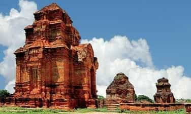
Po Sah Inu Cham Tower
Po Sah Inu is one of three groups of Cham temples and towers belonging to the Hoa Lai artistic architectural style, dating as early as the early 8th to 9th centuries. The group of towers is located on a hill formerly known as Ba Nai hill in Ngoc Lam village, Phu Hai ward (formerly Pho Hai), Phan Thiet city. Next to tower B in the group of towers there is an ancient pagoda, Buu Son pagoda, built in the late 19th century. At the foot of the hill is the sea, to the west of the hill is the surrounding Cai River flowing into the sea. The Po Sah Inu temple tower group has 3 towers including: Main Tower (Tower A), Tower worshiping the Fire God (Tower C) and Tower B worshiping the sacred cow Nandin (still in existence at the end of the 19th century, then lost). This is the only group of temples and towers built on high hills near the sea in the Hoa Lai artistic architectural style of Champa culture, while all other towers are located on high hills or plains far from the sea. . The Main Tower worships the god Siva, inside the tower there is still a Linga - Yoni altar, a symbol of the god, dating from the same time as the tower until now. From the 19th - 20th centuries, many people often called it Pho Hai tower, coinciding with the place name here. From about the 20th century onwards, the Cham people called the tower Po Sah Inu, the name of the princess, biological sister of King Podam and both children of Cham king ParaChanh, whom Vietnamese history called La Khai. After Po Sah Inu passed away, the Cham royal family built a temple to worship her in the grounds of Pho Hai tower. Thus, there was a period when this group of temples and towers existed with two names: Pho Hai and Po Sah Inu. The Main Tower is the largest and tallest tower in the group. The tower is 16m high; There are 3 floors in total, the two upper floors have the same architecture as the lower floor but gradually reduce in size as well as architectural and artistic details. Just like that, gradually getting smaller and soaring to the top along with the tower roof. Halfway up the tower's roof there are 4 vents in 4 directions, to ventilate and exhaust hot air inside the tower, partly creating balance between inside and outside, harmony between gods and heaven and earth. This is the spiritual highlight when dignitaries perform rituals and they believe that the gods from above come back this way. The Main Tower is also a place where the values of physical and mental architecture as well as spirituality and religious beliefs are concentrated. Tower B: The tower is 12m high, has 3 floors like tower A but smaller. Inside the tower worships the sacred cow Nandin, which local people still saw from the late 19th century to the early 20th century, and then no longer saw it. During archaeological excavations from 1991 to 1995, some pieces and feet of the sacred cow Nandin were found. In front of the tower there is a large ceremony yard, currently used to set up a theater during the Kate ceremony. Tower C: Due to its original function of worshiping the Fire God, the architecture has only 1 floor including the base, body and top of the tower, the tower has a height of 5m; The width of each side is nearly 4m. Traces of collapse show that hundreds of years ago until the 80s of the 20th century, the top and roof of the tower collapsed along with the base of the tower rotting deep inside the tower body. After the renovation was completed, the tower's function was reused, but mainly as a place for people to leave offerings before entering the main tower for ceremonies. All three towers in the Po Sah Inu group have been renovated and embellished many times to have the current architectural shape and cultural space. From before until the first half of the 20th century, Cham people often performed many rituals here. Since 2005, the Kate festival has been restored with all the original processes of space, time, form, content and value as before. From the time it was restored until now and forever after, the Kate festival is held regularly every year to join the ancient Po Sah Inu tower in creating a destination to attract tourists and create momentum for tourism development. Source: Propaganda Department of Binh Thuan Provincial Party Committee
Lam Dong
8488 view
Rating : National monument
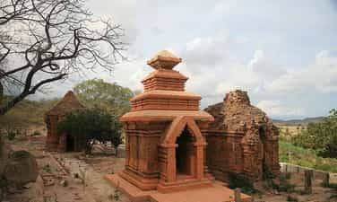
Po Dam Tower
Po Dam Tower in Lac Tri village, Phu Lac commune, Tuy Phong district, Binh Thuan province, is one of the oldest tower clusters of Champa architecture. Po Dam Tower (pronounced Po Tam) was built to worship King Po Dam, also known as Po Kathit (Ban La Tra Duyet) of the Cham people. The Po Dam tower cluster has a very strange structure and layout, it must be said to be the strangest compared to other tower clusters of Champa architecture. The Po Dam tower complex was ranked by the State as a national historical, cultural, architectural and artistic relic in 1996. Instead of being built on top of a hill or on flat land like many other tower clusters, Po Dam tower is located on the side of a hill. The Cham people call it Co Gada, and the Vietnamese in the area call it Ong Xiem hill. Of the 6 towers found, only the South tower (as named by French archaeologist Parmentier) has the main door facing east, towards the rising sun like most Cham towers, the remaining 5 towers in the tower cluster. Po Dam all face South, slightly West. Some researchers explain that the tower door facing that way is to commemorate ancestors, while the south direction is to the other world, the underworld. Anyway, these are two rare phenomena in the history of Cham tower architecture. Po Dam Tower is a cluster of towers built in the 8th century, the same age as Hoa Lai Tower in Ninh Thuan. Over 12 centuries of turbulence, coupled with a rather "unsettled" architectural position, the tower was quite dilapidated. In addition to the two towers on the North axis, which collapsed completely leaving behind only the linga, the remaining 4 towers on the South axis, none of the towers remained intact. Therefore, Binh Thuan province has a plan to reinforce, restore and renovate. In addition to the precious antiques found that the newspapers have reported, such as: pieces of ancient tiles with strange shapes, a set of stone grinding tables (called Rathung patau by the Cham people), two bronze mata rings, a bell small bronze, 1 iron ax, 1 copper-printed rattle, under the North tower shaft, people also found a yellow bowl (pata - patil) (possibly made of bronze or gold) and especially a skeleton that could is the remains that legend says belongs to the king's mother, Po Bia Than. Her grave - like that of Bia Than Cih in Po Rome Tower in Ninh Thuan - was later covered. In the south of the South axis tower, after excavation, the entire base with important relics is also visible. Po Dam Tower is one of the oldest and most strangely structured tower clusters in ancient Champa architecture in the southernmost region of this kingdom. Moreover, it is a cluster of living towers, meaning they are worshiped and worshiped every year by the Cham community in the area. Archaeological excavation is necessary to discover traces that corroborate history and collect artifacts to enrich the country's museums. But what is more necessary is how to restore the tower without damage and especially without being mixed, keeping the sacred part of the tower as its true Cham tower. Source: Binh Thuan Tourism
Lam Dong
4900 view
Rating : National monument
Outstanding monuments
See all
Relics of Resistance Base Area 6 Cat Tien
The historical relic site of resistance base in Cat Tien zone VI has a total area of nearly 50 hectares, located in village 5, Duc Pho commune, Cat Tien district, Lam Dong province. This is an ideal address to attract people and tourists who love nature, explore and learn about history and national revolutionary traditions. Area VI relic, Cat Tien is a work of important historical significance, recording the merits and achievements of generations of ancestors in the struggle against the American invaders, period 1963 - 1966. Mold The relic site of Area VI, Cat Tien is designed harmoniously, scientifically and beautifully, suitable for the landscape space, with a system of clean, beautiful concrete-paved internal roads winding around cool, green ponds and lakes; The majestic monument located on the top of the central hill has created a highlight that attracts the attention of people and tourists when visiting the relics of Area VI, Cat Tien. Not far from Monument Hill is a display house with 108 collected artifacts and a number of primitive weapons restored for display and explanation. Scattered on the green hillsides shaded by forest trees are buildings of camps and shelters recreating the working and living spaces of "Region and Military Region Party Committee agencies" with a total of 23 categories. categories, in which, the Regional Party Committee agency has 12 categories and the Military Region agency has 11 categories. According to historical documents, in the period from 1963 - 1966, Cat Tien Party Committee and Zone VI made important contributions marking the continuous growth of our country's revolutionary forces. In the beginning, Area VI was the place to focus on consolidating and preparing the necessary conditions to coordinate with the entire South to attack the enemy, destroy strategic hamlets, expand the controlled and liberated areas, and create position and force. for the Vietnamese revolutionary movement to win great victories. Especially in the Winter - Spring of 1964 - 1965, the revolutionary movement in Area VI had a leap forward in both width and depth; The army and people of Zone VI proactively coordinated with the entire South to attack the enemy in the Dong Xoai campaign in the summer of 1965, contributing to the bankruptcy of the US imperialism's "special war" strategy. In the dry season of 1965 - 1966, the army and people of Zone VI defeated the enemy's first counterattack in the Zone VI battlefield. From here, the army and people of Zone VI continuously failed the enemy's pacification and search-and-destroy plan in the second strategic dry season counterattack (1966 - 1967). By the dry season of 1967 - 1968, the army and people of the Zone VI stepped up its attacks and won great victories. From mid-1965 to the end of 1968, the Party Committee, army and people of Region VI coordinated with the entire region to defeat the "Local War" strategy of the US imperialists. The victories of the army and people of Zone VI - Cat Tien demonstrate the Party's ingenious and wise leadership. Among them, the ethnic community of Zone VI was united, heroic, and indomitable, achieving resounding victories, demonstrating the brilliance of revolutionary heroism, and with passionate patriotism helping the army. and the people of Area VI overcame countless difficulties and challenges, winning victory after victory in the resistance war against the US to save the country, contributing to completely liberating the South and reunifying the country. The construction and embellishment of the historical relics of the resistance base of Zone VI, Cat Tien has shown the spirit of drinking water, remembering the source, honoring and promoting the great historical values of the army and people of Zone VI, and the community. This is the place to educate, train and foster revolutionary traditions for future generations. Source: Cat Tien District Electronic Information Page
Lam Dong
9770 view
Rating : Special national monument

Da Lat Children's Prison
Da Lat Children's Prison was built by the old regime with the beautiful name: "Da Lat Children's Training Center". at No. 9A, Xuan Huong Lake, Da Lat city, Lam Dong province. This revolutionary historical relic was recognized by the Ministry of Culture, Sports and Tourism as a National Monument on June 22, 2009. "Da Lat Children's Education Center" was established in early 1971. The old regime used demagogy to deceive public opinion, covering up sinister plots to isolate, suppress, and eventually eliminate the elite. revolutionary spirit of the young generation in the South. This "center" is actually a children's prison, fully demonstrating the nature of an imperial prison. This special prison once detained more than 600 children from 12 to 17 years old with revolutionary spirit, gathered from all prisons in the South. The prison is designed as a closed rectangular block surrounded by stone walls. The two rows of houses along both sides are mainly cells and cells; The horizontal rows of houses create two courtyards in the middle to serve prisoners' activities when outside the cell. When allowed to sunbathe in the yard, prisoners are only allowed to move within small boxes marked on the yard adjacent to the entrance of each cell. In front is a normal A-shaped block, which is the office of the prison management apparatus. All activities of child prisoners are closed behind, within solid stone walls, with many rolls of thick barbed wire on the roof, only communicating with the outside through 2 layers of solid doors but barely always closed. Through the two doors of the A-shaped block is the flag yard area, the flagpole at that time permanently hung the flag of the Saigon government. Every morning at the beginning of the week, all child prisoners must gather here to salute the flag and sing the national anthem. Those who oppose, do not salute the flag, or sing the national anthem will be tortured until they submit. The prison has 8 cells, divided into 2 areas: the male prisoner area has 6 rooms and the female prisoner area has 2 rooms. Each room's area is about 30 square meters, usually holding 60 - 70 prisoners, with some rooms holding nearly 100 prisoners at peak times. At the end of the corridor of the two cell blocks are rows of solitary cells holding dissident soldiers. In particular, there was a stone cellar hidden behind the cell corridor, with no roof but only a thick barbed wire mesh on top for the enemy to carry out the dew and sun exposure punishment of prisoners. On April 23, 1971, the Saigon government sent 126 children prisoners from Ammunition Prison (Da Nang) to the Da Lat Children's Training Center, marking the official operation of this prison. After that, child prisoners from Hoi An, Quang Ngai, Binh Dinh, Phu Yen, Ben Tre... continued to be transferred; Especially at the end of 1971, the Saigon government gathered young revolutionary soldiers imprisoned in Con Dao prison and Chi Hoa prison to be detained here. From here, the young revolutionary soldiers gathered core forces, established a unified command, and set out specific demands to carry out continuous, persistent, and thorough fighting measures. the prison's existence process. During the struggle, even at a young age, child prisoners were still brutally abused and tortured in many forms: cross-cuffed, beaten with whips braided from electric wire, barbed wire, scout sticks, or Use a hot high-voltage electric bulb to press on your face... In the cell, in the middle of a cold Da Lat night, the temperature dropped below 15 degrees Celsius, the enemy also poured cold water to torture prisoners in solitary confinement. The young soldiers had to sleep on the cement floor, sharing each grain of rice, sip of water, bed... Young soldiers have also organized prison escapes seven times, expressing their desire for freedom and the desire to return to continue fighting. A shocking event at Da Lat children's prison on the evening of January 23, 1973 was when children prisoners organized to destroy prison guard Nguyen Cuong, who was willing to be a lackey for the enemy. It was the courageous and indomitable fighting movement of young revolutionary soldiers that failed the enemy's sinister plot to establish this prison, forcing it to disband in mid-1973. After the day of national reunification in 1975, former prisoners of Da Lat children's prison scattered to localities, continuing to promote the tradition of indomitable struggle in prison, actively contributing to the cause of building and preserving the country. protect the country. With particularly outstanding achievements in the cause of fighting the US to save the country, in 2009, the collective of former prisoners of Da Lat children's prison was awarded the title of Collective Hero of the People's Armed Forces by the President. The national relic of Da Lat Children's Prison (1971 - 1973) has now become a meaningful tourist destination in Lam Dong province. This is a "red address" in educating revolutionary ideals, patriotic traditions, and national pride for the young generation. Source: Lam Dong Museum
Lam Dong
9370 view
Rating : National monument

The historical site connects the Central Highlands to the Southeast
The historical relic of Cay Xoai village is a contact point to open the North-South strategic corridor, the section through Dak Nong province. On May 25, 1959, the Central Military Commission and the Ministry of National Defense officially established Group B90, with the mission of secretly going to the South with on-site units to build facilities and open two routes to the East and West. from the Southern Central Highlands to the Southeast region - where the Southern Party Committee is located. Overcoming difficulties, sacrifices and even unsuccessful connection trips, finally, at about 4:00 p.m., October 30, 1960, the B90 Working Group made contact with the C200 working group of the Southeast region. Ministry at Cay Xoai village, Dak Nia commune, City. Gia Nghia, Dak Nong province. On November 4, 1960, at kilometer 4 on the Dak Song to Gia Nghia road, the western wing of Group B90 continued to make contact with unit C270 from the Southeast. This is an event of particularly important strategic significance. The North-South strategic corridor was opened, becoming an important node to help smooth the Ho Chi Minh route, from here, the transport route Military strategy Ho Chi Minh Road is like a lifeline running from North to South, providing timely human and material resources from the great rear of the socialist North to the great front line of the South, making a decisive contribution to victory. greatness of the resistance war against the US to save the country. From 1961 to 1965, the Ho Chi Minh Trail was smooth, and tens of thousands of Southern compatriots gathered to go to the North and returned to the battlefield; A series of essential items such as parcels, official documents, weapons, ammunition, including liberation radio equipment... were urgently transported by soldiers between the East and West wings. provide support for the battlefields of the South and the extreme South Central region; Transporting high-ranking Party officials to the South to lead the masses in the fight against America. After a period of operation, the base in the Southern Central Highlands was expanded and connected to areas with bases in Tay Khanh Hoa, Tay Ninh Thuan, Dak Lak, Lam Dong and connected from Dak Mil to war zone D. In addition, the Quang Duc corridor force coordinated with Cambodia to expand the control area along the corridor, creating effective continuity and coordination across battlefields during the resistance war. To achieve the miracle of connecting the battlefields, making an important contribution to the great victory of the resistance war against the US, it is impossible not to mention the role of ethnic people in the area who sacrificed their lives, arduously protecting the corridor, protecting forces participating in military transport on Truong Son road, hiding officers, protecting the revolution, ensuring smooth operations. These are the boys and girls of Group H50 who stick to the road, despite hardships and deprivation; They are groups of local civilians who secretly carry goods and weapons to overcome high passes, steep slopes, muddy fields and dangerous posts; That is the image of 800 compatriots at Nam Nung base having to eat forest leaves and tubers to save rice, corn, potatoes, and cassava to help the road construction team and officers and soldiers walking on the corridor, despite the dangers to get there. raise troops, protect revolutionary soldiers... Cay Xoai village historical relic "Place to establish communication to open the North-South strategic corridor, section through Dak Nong province" is one of the historical places associated with the miracle of the 20th century - Duong Truong Son, invested in construction by the State and completed on March 23, 2010. On August 2, 2011, the Ministry of Culture, Sports and Tourism recognized this as a national revolutionary historical relic. On October 30, 2017, the People's Committee of Dak Nong province organized a memorial ceremony and placed a stele listing the list of officers and soldiers who participated in fighting and sacrificed their lives in carrying out the tasks of construction and protection. North-South strategic corridor, in Cay Xoai village, Dak Nia commune, City. Gia Nghia, Dak Nong province. Source: Party Committee of Agencies and Enterprises of Dak Nong Province
Lam Dong
9194 view
Rating : National monument

Duc Thanh School
Duc Thanh School Where teacher Nguyen Tat Thanh (Uncle Ho's name at the age of 20) taught in 1910, before going abroad to Saigon to find a way to save the country. Duc Thanh School, formerly known as Duc Thanh Hoc Hieu, was established in 1907. Located in Thanh Duc village, 39 Trung Nhi Street, Duc Nghia Ward, Phan Thiet City, the school is near Ca Ty River. wonderful and peaceful. Duc Thanh Hoc Hieu was born thanks to the patriotism of scholars and Confucian scholars in Central Vietnam. Construction funding came from the generosity of Mr. Huynh Van Dau and Lien Thanh Thuong Quan. All students here study for free. This is a private school with progressive teaching content in Binh Thuan province at that time. Lien Thanh Thuong Quan (Lien Thanh company) was a patriotic organization in the early 20th century. Operating in the economic field. Duc Thanh Hoc opened a class to teach patriotic content according to progressive ideology for children of patriots and poor workers, in response to the Duy Tan movement initiated by Phan Chau Trinh, Tran Quy Cap and Huynh Thuc Khang in Vietnam. Mid-term. Lien Thanh Company operated effectively, secretly contributing part of its finances to Phan Boi Chau's Dong Du movement. Lien Thanh commune, led by Nguyen Hiet Chi, invited many speakers to give speeches, including Phan Chau Trinh, causing a lively buzz. In particular, Duc Thanh school has trained a class of young people to study according to the new books and spirit. In 1910, Nguyen Tat Thanh was introduced by his colleague Truong Gia Mo and came to Phan Thiet to teach at this school. At that time, the school had about 60 students and 7 teachers teaching subjects: Chinese literature, French literature, physical education... One of the school's students was Nguyen Kinh Chi, son of Nguyen Hiet Chi, later a doctor. , Deputy Minister of Health of the Democratic Republic of Vietnam, National Assembly delegate of the 1st - 4th term, is a direct student of teacher Nguyen Tat Thanh. Nguyen Tat Thanh teaches second grade, mainly teaching Vietnamese and Chinese characters. During this time, in addition to the content assigned to teach, Nguyen Tat Thanh also spread love for his homeland, country and ancestral race to students. During extracurricular classes or free time, Nguyen Tat Thanh also leads his students to visit beautiful scenery in Phan Thiet such as Thuong Chanh beach, Thieng village cave, Duc Nghia village communal house. In February 1911, Nguyen Tat Thanh left Duc Thanh and Phan Thiet schools to enter Saigon. A year later, there was no one left in charge and for many other objective reasons, the school closed in 1912. The architecture of Duc Thanh school bears bold Asian traditions. The school has three houses, including two large houses for classrooms and one upstairs house. In the classroom, there are wooden tables and chairs below, and above is a blackboard for teaching. The school campus is a lush green garden, neatly and carefully cared for. To the right of the main house, is the Ngu house used as a boarding house for students and teachers. Ngoa Du Sao is an area for receiving guests and discussing poetry, located right behind the classroom and the Ngu House. On the school campus there is a well for drinking water. Source: People's Committee of Binh Thuan province
Lam Dong
9079 view
Rating : National monument

Po Sah Inu Cham Tower
Po Sah Inu is one of three groups of Cham temples and towers belonging to the Hoa Lai artistic architectural style, dating as early as the early 8th to 9th centuries. The group of towers is located on a hill formerly known as Ba Nai hill in Ngoc Lam village, Phu Hai ward (formerly Pho Hai), Phan Thiet city. Next to tower B in the group of towers there is an ancient pagoda, Buu Son pagoda, built in the late 19th century. At the foot of the hill is the sea, to the west of the hill is the surrounding Cai River flowing into the sea. The Po Sah Inu temple tower group has 3 towers including: Main Tower (Tower A), Tower worshiping the Fire God (Tower C) and Tower B worshiping the sacred cow Nandin (still in existence at the end of the 19th century, then lost). This is the only group of temples and towers built on high hills near the sea in the Hoa Lai artistic architectural style of Champa culture, while all other towers are located on high hills or plains far from the sea. . The Main Tower worships the god Siva, inside the tower there is still a Linga - Yoni altar, a symbol of the god, dating from the same time as the tower until now. From the 19th - 20th centuries, many people often called it Pho Hai tower, coinciding with the place name here. From about the 20th century onwards, the Cham people called the tower Po Sah Inu, the name of the princess, biological sister of King Podam and both children of Cham king ParaChanh, whom Vietnamese history called La Khai. After Po Sah Inu passed away, the Cham royal family built a temple to worship her in the grounds of Pho Hai tower. Thus, there was a period when this group of temples and towers existed with two names: Pho Hai and Po Sah Inu. The Main Tower is the largest and tallest tower in the group. The tower is 16m high; There are 3 floors in total, the two upper floors have the same architecture as the lower floor but gradually reduce in size as well as architectural and artistic details. Just like that, gradually getting smaller and soaring to the top along with the tower roof. Halfway up the tower's roof there are 4 vents in 4 directions, to ventilate and exhaust hot air inside the tower, partly creating balance between inside and outside, harmony between gods and heaven and earth. This is the spiritual highlight when dignitaries perform rituals and they believe that the gods from above come back this way. The Main Tower is also a place where the values of physical and mental architecture as well as spirituality and religious beliefs are concentrated. Tower B: The tower is 12m high, has 3 floors like tower A but smaller. Inside the tower worships the sacred cow Nandin, which local people still saw from the late 19th century to the early 20th century, and then no longer saw it. During archaeological excavations from 1991 to 1995, some pieces and feet of the sacred cow Nandin were found. In front of the tower there is a large ceremony yard, currently used to set up a theater during the Kate ceremony. Tower C: Due to its original function of worshiping the Fire God, the architecture has only 1 floor including the base, body and top of the tower, the tower has a height of 5m; The width of each side is nearly 4m. Traces of collapse show that hundreds of years ago until the 80s of the 20th century, the top and roof of the tower collapsed along with the base of the tower rotting deep inside the tower body. After the renovation was completed, the tower's function was reused, but mainly as a place for people to leave offerings before entering the main tower for ceremonies. All three towers in the Po Sah Inu group have been renovated and embellished many times to have the current architectural shape and cultural space. From before until the first half of the 20th century, Cham people often performed many rituals here. Since 2005, the Kate festival has been restored with all the original processes of space, time, form, content and value as before. From the time it was restored until now and forever after, the Kate festival is held regularly every year to join the ancient Po Sah Inu tower in creating a destination to attract tourists and create momentum for tourism development. Source: Propaganda Department of Binh Thuan Provincial Party Committee
Lam Dong
8488 view
Rating : National monument

Dak Mil Prison
Located along Highway 14, about 60 km from the center of Gia Nghia town, Dak Mil prison, located in Dak Mil district, is a majestic historical relic still bearing the mark of time. Dak Mil Prison, recognized as a National Historical Site on March 17, 2005. In 1940, the Revolutionary movement broke out all over the country, due to the increasing number of political prisoners at Buon Ma Thuot Prison and to serve the construction of the road through the M'Nong plateau next to Buon prison. Ma Thuot French colonialists also built Dak Mil Prison, (now in Dak Mil district, Dak Nong) in the middle of an old forest, where the sacred forest and poisonous water were used to imprison political prisoners. Dak Mil Prison, became a revolutionary base in the district and witnessed many escapes by Vietnamese Communist soldiers. From 1940 to 1943, this place detained hundreds of communist soldiers, at one time up to 120 people. Revolutionary soldiers exiled to Dak Mil Prison, from 1941 to 1943: Chu Hue, Ho Tung Mau, Nguyen Tao, Tran Huu Doanh, Truong Van Linh, Nguyen Khai, Tran Tong, Le Nam Thang... At the end of 1943, the French transferred all the prisoners here to Buon Ma Thuot prison and destroyed Dak Mil prison. Dak Mil Prison, in ancient times, was built on a piece of land in the middle of the gloomy mountains and forests of Dak Mil district. Outside the 9-room wooden prison with a thatched roof is a wooden fence secured with barbed wire. Inside the Prison, the walkway is located between two rows of wooden floors with enough foot shackles and hand shackles, each shackle has 4 bamboo pipes hanging: 2 upper pipes for drinking water, 2 lower pipes for urine and feces. Over a long period of time, Dak Mil Prison was dilapidated and became ruins. Currently, on December 31, 2010, after more than two years of restoration, Dak Nong province completed the restoration and construction of the Dak Mil Prison National Historical Site, in village 9A, Dak Lao commune. (Dak Mil). The project is invested by the Ministry of Culture, Sports and Tourism with a total cost of over 9 billion VND. The entire relic is located in the middle of a crowded residential area with an area of nearly 1 hectare, with two main items: the prison and the exhibition house of artifacts. The prison has been recreated with an area similar to the prison previously built by the French colonialists, and the old foundations still remain. Source: Dak Mil District Electronic Information Page,.
Lam Dong
6965 view
Rating : National monument

Bao Dai Palace 1
Da Lat is famous for 3 palaces during King Bao Dai's reign: Palace 1, Palace 2, Palace 3, associated with the ups and downs of our country's history. In 1940, a French millionaire named Robert Clément Bourgery built Palace 1. In 1949, King Bao Dai's father-in-law contributed money for the king to buy this mansion. King Bao Dai set up his General Headquarters here to work during his years as Head of State from 1949 to 1954. Besides Da Lat, King Bao Dai also owns another very famous mansion in Vung Tau, which is Bach Dinh. In 1956, Palace 1 was transferred to Ngo Dinh Diem for use. Many years later, this place became a resting place for heads of state until 1975. In 2014, the local government invested in restoring and repairing Palace 1, making this place available for sightseeing. vacation in Da Lat. Palace 1 of Da Lat (Bao Dai Palace) has undergone many renovations. The outside campus is spaciously designed and equipped with luxurious tables and chairs. Stepping through the gate into the campus, there are hundreds of blooming flowers, a giant flag garden, 7-color steps, hundreds of hanging lanterns... The fountain has a bold European feel as well. attracts many tourists. Stepping up to the first floor, in addition to the main lobby area, on both sides of the palace are 2 large living rooms, behind are 4 rooms of different sizes. In the past, these rooms were used as transition rooms, clerical rooms, kitchens and WCs. At the end of the first floor is a very majestic and magnificent photography room. Including a throne, a hammock painted in red and gold... When you step up to the 2nd floor of Bao Dai Palace 1, you will see 3 different bedrooms. The first room is the bedroom of King Bao Dai's mother (Mrs. Tu Cung). The second room is King Bao Dai's bedroom. Next is Queen Nam Phuong's bedroom, located opposite the palace hallway. It can be said that the second room is the most important in King Bao Dai's first palace. This is where important meetings took place during the reign of King Bao Dai from 1949 to 1954. This is also the place to discuss campaigns and wars from 1955 to 1963. During Ngo Dinh Diem's government, he renovated King Bao Dai's room and dug a secret tunnel here. The path down to the tunnel is disguised to look like a bookshelf to the right of the bed. This exit leads to the helipad behind the hill of palace 1. Especially in this mansion are military-style constructions, you will not help but be surprised and overwhelmed by its unique appearance. First is a large helicopter landing pad, gas depot, and emergency exit (tunnel). The tunnel door is equipped with metal weighing several hundred kilograms, artillery, bulletproof glass... Source: Da Lat tourism information portal
Lam Dong
6259 view
Rating : National monument

Phan Thiet Water Tower
Phan Thiet water tower located on the Ca Ty river was built nearly 90 years ago, designed by Prince Xuphanuvong (Laos), and is currently a symbol of Binh Thuan province. Phan Thiet Water Tower (also known as "Water Tower") was built by the French from 1928-1934 according to the urban planning policy of the contemporary government, serving to provide domestic water for the French Legation (now the headquarters of Binh Thuan People's Committee) and people in Phan Thiet city. The location for the water tower is located on the land of Long Khe village, on the left bank of the Ca Ty river, high and airy, about 350 meters from the Legation Palace. The design of the water tower was drawn by Prince Xuphanuvong (Laos, who was then an international student at Albert Sarraut School in Vietnam), approved by the Hanoi Department of Public Works and the project was put out for bidding. Among two French contractors and two Vietnamese contractors, contractor Ung Du (originally from Hue, working in Binh Thuan) won the bid. The water tower is built in a regular octagonal cylinder. The height from the base to the top of the tower is 32 m. The whole is divided into 3 parts, including: the tower body, the platform and the roof. The tower's body has an octagonal cylindrical shape, each side is 3.9 m wide, the higher it goes, the smaller it becomes. The diameter of the tower's base is 9 m long, the circumference is 31.2 m, and the floor area is 73.4 m2. Along the edges of the tower's body, from top to bottom, there are 5 ventilation boxes decorated with seal patterns corresponding to the 5 words: "Happiness", "Phuc", "Tho", "Kiet", "Loc" . The meaning is to wish all people joy, happiness, longevity, prosperity and prosperity. Particularly, the west side of the ventilation box with the word "Loc" is replaced by an iron door entering and exiting the tower. The platform, that is, the water tank, is also designed in an octagonal shape, 5 m high, 9 m in diameter, containing 350 m3 of water. Around the platform, there are 8 circles embossed with pieces of porcelain stylized with the four letters U.E.P.T, which stands for the French phrase "Usine des Eaux de Phan Thiet" (meaning Phan Thiet Water Plant). With its high architectural features, the building is also used as a flagpole. Master Nguyen Chi Phu, Deputy Director of Binh Thuan Provincial Museum, said that during the construction process, experts and workers strictly followed the technical design. Gravel must be washed 5 times to remove sand and dust. Foundry sand must also be washed 3 times to remove dirt. Cast iron must be rubbed with sandpaper to remove rust. Boards used for formwork must be planed smooth so that when removed, there is no need to add any additional plaster. Thanks to that, the project is sturdy and durable until today. After nearly 90 years of existence, even in the face of war bombs and harsh environments, especially through two historic floods in the years of Nham Thin (1952) and Quy Dau (1993), the water tower still stands majestically in the heart of the city. The city, becoming a sacred symbol, entered the poetry and music of the coastal land of Phan Thiet. On October 19, 2018, Phan Thiet water tower was decided to rank as a provincial monument by the Binh Thuan People's Committee. Source: Phan Thiet Tourism
Lam Dong
5919 view
Rating : Provincial level relics

Xuan Huong Lake Relics
When mentioning Da Lat, no one knows about Xuan Huong Lake, a beautiful lake located right in the center of Da Lat city. Xuan Huong Lake is an artificial lake, with a circumference of about 5km and 25ha wide. The lake has the shape of a crescent moon, stretching more than 2 km and passing through many famous tourist attractions of Da Lat such as the City Flower Garden, Yersin Park, Cu Hill and Lam Vien Square. According to people here, the origin of the name Ho Xuan Huong comes from two different legends. The first legend says that every spring, there is a faint, fragrant scent around the lake, ecstatic. That's why people gave the lake the name Xuan Huong Lake. However, the second legend says that Ho Xuan Huong was named after a 19th century Vietnamese female poet named Ho Xuan Huong. Ho Xuan Huong is the author of a number of famous poems such as Floating Water Cake, Life as a Monk, Debt to Husband and Children,... Xuan Huong Lake was originally a large valley, and Cam Ly stream flowed through. In 1919, engineer Labbe blocked this stream so that water could accumulate and form a lake. Then, in 1923, French engineers built a dam at the bottom of the lake, but it broke after a storm in 1932. Engineer Tran Dang Khoa then rebuilt a new dam. made of stone. In 1989, Xuan Huong Lake was recognized by our state as one of the famous landscapes and historical relics in Da Lat, ranked as a national monument. Source: Da Lat tourism information portal
Lam Dong
5469 view
Rating : National monument

Dalat Railway Station
Da Lat Station is not only a unique architectural work of Da Lat city, but also a place that makes a special mark in the history of Vietnam Railways. Da Lat Station is located on Quang Trung Street (Ward 10, Da Lat City, Lam Dong Province), also the only train station in the Central Highlands region. Da Lat Station is associated with the history of formation and development of the "land of thousands of pines" urban area, considered the most beautiful ancient train station in Vietnam and Indochina. Da Lat Station was built from 1932 to 1938, located on the Thap Cham - Da Lat railway, connecting the plateau city with Phan Rang (Ninh Thuan). This railway line is 84km long, with an elevation difference of 1,500m, and was started in 1908 by order of Governor General of Indochina Paul Doumer. In 1932, the route was completed, which was also the time to build Da Lat station. The entire route has 12 stations and 5 underground tunnels. It is a special railway because it has 16km of cog railway climbing steeply, with an average slope of 12%. At that time, railways and locomotives with cog wheels only existed in Switzerland and Vietnam. In 1972, this railway line was destroyed by war. In 1975, the country was unified, this line was restored but only operated for a short time due to poor economic efficiency. The rail system and cog railway tracks were removed. The stations were abandoned. Dalat Railway Station was designed by two French architects, Moncet and Revéron, with bold indigenous architecture. The structure of the project is coherent and scientific, but the form is very sophisticated. The building has a symmetrical layout, with the architectural block in the middle simulating the three peaks of Langbiang Mountain and the roofs of the Central Highlands' communal houses; On both sides are two sprawling architectural blocks. In the middle of the building, outside, under the roof, there is a large clock face recording the time Dr. Alexan Dray Yersin discovered Da Lat. In the middle block, there are two front halls, one for passengers and one for cargo. Between these two paths is the train waiting area. This middle architectural block has only 1 floor with large space and a height up to the roof. Overall, the building's architecture is in harmony with nature and is a unique urban highlight. Da Lat Station was recognized as a national historical and cultural relic in 2001. Currently, Da Lat station has been separated from the Vietnam national railway system, but is still an attractive tourist destination. The station maintains a tourist train consisting of 1 locomotive and 4 carriages going back and forth to Trai Mat station (ward 11, Da Lat city), located in the east, 7km from Da Lat, about 25 minutes away. On this road, visitors can admire the romantic suburban landscape of the city. At the last stop is Trai Mat station, visitors can visit Linh Phuoc Pagoda (also known as Ve Chai Pagoda) - a famous and unique pagoda. In addition, Da Lat station still sells intermodal tickets on the Thong Nhat railway, departing from Nha Trang station (Khanh Hoa) and serving Da Lat - Nha Trang transit cars. Along with famous works of Da Lat such as: Cathedral, Bao Dai Palace, Da Lat Pedagogical College..., Da Lat Station is a destination not to be missed for tourists coming to the city. Da Lat. There is also an antique steam locomotive on display and a cafe located in a train car. The station's romantic scenery and ancient architecture is a place where many people come to "hunt" for beautiful photos Source: Vietnam National Tourism Administration
Lam Dong
5452 view
Rating : National monument